
Soil/Landform Unit - Donald lake and lunette cluster
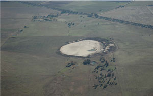 Lake and lunette west of Donald |
0.20% of CMA region Scattered throughout the north-east of the region are a number of lake-lunette clusters that fall within the Calcareous North Western Dunefields and Plains where hummocky dunes are sub-dominant (5.1.5). Lakes including playa plains and lunettes are relatively small features in a broader landscape context than Lake Albacutya and Hindmarsh to the west. Soils include sodic red texture contrast soils (Sodosols) and cracking clay soils (Vertosols) on the plains and lake floors with calcareous gradational soils (Calcarosols) common on lunettes. Land use is varied between nature conservation, dryland cereal cropping and grazing with periodic waterlogging likely in wet winters and springs. A variety of vegetation types are found in these areas including Low Rises Woodland, Ridged Plains Mallee, Riverine Chenopod Woodland, Plains Grassland, Plains Woodland and Plains Savannah. | 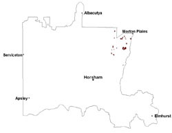 |
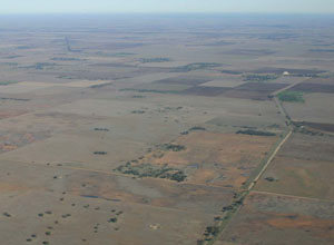 Looking west along the Borung Highway towards Carron | 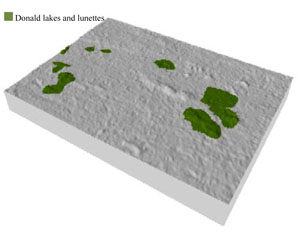 |
 |  Lake Watchem |
Component | 1 | 2 | 3 |
Proportion of soil-landform unit | 20% | 60% | 20% |
| CLIMATE Rainfall (mm) | Annual: 370 | ||
| Temperature (oC) | Minimum 9, Maximum 22 | ||
| Precipitation less than potential evapotranspiration | September–April | ||
| GEOLOGY Age and lithology | Quaternary alluvium, silt, sand and minor gravel (Shepparton Formation); Neogene marine sand and silt (Parilla Sand) | ||
| Geomorphology | |||
| LANDUSE | Uncleared areas: water supply; nature conservation; recreational activities (e.g. swimming) Cleared areas: dryland cropping; sheep grazing | ||
| TOPOGRAPHY Landscape | Lake-lunette cluster | ||
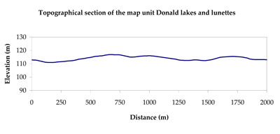
| Elevation range (m) | 93–135 | ||
| Local relief (m) | 5 | ||
| Drainage pattern | Centripetal | ||
| Drainage density (km/km2) | 0.5 | ||
| Landform | Lake-lunette clusters | ||
| Landform element | Playa lake/swamp | Undulating plain | Lunette |
| Slope and range (%) | 1 (0-3) | 5 (3-10) | 6 (1-12) |
| Slope shape | Convex | Linear | Concave |
| NATIVE VEGETATION Ecological Vegetation Class | Plains Woodland (31.3%), Plains Savannah (29.5%), Riverine Chenopod Woodland (12.8%), Low Rises Woodland (8.6%), Other (17.8%) | ||
| SOIL Parent material | Swamp silt and clay | Marine and alluvial silt, sand and minor gravel | Aeolian clay, silt and sand |
| Description (Corangamite Soil Group) | Cracking clay soils (34) | ||
| Soil type sites | |||
| Surface texture | Medium clay | Sandy loam to light clay | Sandy clay loam |
| Permeability | Moderate | Moderate | Moderate |
| Depth (m) | > 3 | > 3 | > 2 |
| LAND CHARACTERISTICS, POTENTIAL AND LIMITATIONS Critical land features, processes, forms | High clay content results in restricted soil drainage, but can be variable due to micro relief (gilgai). Surface soils are friable and only slightly susceptible to wind erosion due to self-mulching and massive nature. Soils may be susceptible at critical moisture contents and have variable resilience to compaction. | Hardsetting surface susceptible to sheet and rill erosion along with wind erosion. Variable clay content results in restricted soil drainage, but can be due to micro relief (gilgai). Dispersive and deep subsoils. Soils are prone to compaction at critical moisture contents. | Well drained surfaces that can be imperfect at depth. Subsoil may be dispersive and subject to erosion where exposed. Surface soil may be susceptible to sheet and wind erosion where exposed. Soils are prone to compaction at critical moisture contents. |
© State of Victoria (Agriculture Victoria) 1996 - .

This work, Victorian Resources Online, is licensed under a Creative Commons Attribution 4.0 licence. You are free to re-use the work under that licence, on the condition that you credit the State of Victoria (Agriculture Victoria) as author, indicate if changes were made and comply with the other licence terms.
The licence does not apply to ‘branding’ or some ‘images or photographs’ that may be owned by third parties. We ask you to seek prior approval to use images using the VRO feedback form. Access to higher quality images can also be provided on request.
This page was last updated on .