Site IS15
Location: Murtoa
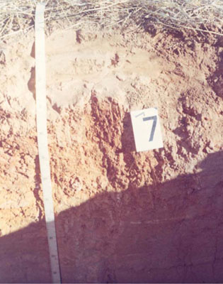
Australian Soil Classification: Calcic, Mottled-Mesonatric, Red SODOSOL
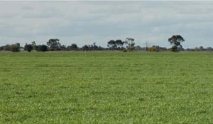
General Landscape Description: Terrace flat within an anastomotic plain.
Geology: Quaternary Shepparton Formation: fluvial silt, sand and minor gravel
 IS15 Landscape |
Soil Profile Morphology:
Surface soil
| A1 | 0-5 cm | Brown (7.5YR4/4); fine sandy loam; plastic; hard setting surface condition; weak coarse granular structure; weak consistence dry; pH 6.2; sharp and wavy boundary to: |  IS14 Profile |
| A2e | 5-10 cm | Brown (7.5YR4/4) conspicuously bleached (7.5YR7/2d); fine sandy loam; weak coarse granular structure; weak consistence dry; pH 8.2; sharp and wavy boundary to: | |
| A3e Subsoil | 10-15 cm | Conspicuously bleached (7.5YR7/2d); sandy loam; massive (structureless) with cemented capping; weak consistence dry; pH 8.2; sharp and wavy boundary to: | |
| B21 | 15-50 cm | Yellowish red (5YR5/6) with (2.5YR4/4) mottles; medium clay; plastic; moderate very coarse columnar structure; strong consistence dry; sticky consistence wet; pH 9.3: | |
| B22 | 50-90 cm | Yellowish red (5YR5/6) with (2.5YR4/4) mottles; medium clay; plastic; moderate very coarse columnar structure; strong consistence dry; sticky consistence wet; pH 9.8; clear and wavy boundary to: | |
| B31k | 90-140 cm | Yellowish brown (10YR5/4); sandy clay loam; plastic; weak coarse subangular blocky structure; strong consistence dry; moderately sticky consistence wet; few (2-10%) soft carbonate segregations in bands; pH 9.8. |
Horizon | Sample Depth cm | pH | EC dS/m | Sodium Chloride % | Exchangeable Calcium cmol-/kg | Exchangeable Magnesium cmol-/kg | Exchangeable Potassium cmol-/kg | Exchangeable Sodium cmol-/kg | Exchangeable Aluminium mg/kg | Exchangeable Acidity cmol-/kg | Field Capacity -30okPa | Permanent Wilting Point -1500okPa | Coarse Sand % | Fine Sand % | Silt % | Clay % | |
H2O | CaCl2 | ||||||||||||||||
A1 | 0–5 | 6.2 | NA | 0.09 | 0.01 | 1.7 | 0.6 | 0.7 | 0.1 | NA | 3 | NA | 3.6 | 7 | 68 | 15 | 8 |
A2e | 5–10 | 6.2 | 5 | 0.06 | 0.01 | 2.8 | 0.9 | 0.4 | 0.1 | NA | 2.1 | 15.1 | 2.7 | 8 | 69 | 15 | 8 |
A3e | 10–15 | 8.2 | NA | 0.09 | 0.02 | 1.9 | 2.1 | 0.4 | 0.8 | NA | 0.9 | NA | 5.2 | 6 | 61 | 18 | 15 |
B21 | 15–50 | 9.3 | NA | 0.39 | 0.04 | 4.3 | 8.3 | 1.4 | 4.2 | NA | NA | NA | 17.1 | 3 | 37 | 16 | 44 |
B22 | 50–90 | 9.8 | NA | 0.57 | 0.06 | 1.4 | 5.3 | 0.7 | 4.5 | NA | NA | 30.4 | 10.9 | 1 | 51 | 22 | 26 |
B31k | 90–140 | 9.8 | NA | 0.36 | 0.04 | 1 | 3.6 | 0.4 | 3 | NA | NA | NA | 20 | 1 | 69 | 14 | 16 |
B32 | 140–195 | 9.8 | NA | 0.32 | 0.03 | NA | NA | NA | NA | NA | NA | NA | 8.7 | 1 | 61 | 19 | 19 |
B33 | 195–230 | 8.9 | NA | 0.23 | 0.04 | NA | NA | NA | NA | NA | NA | NA | NA | 15 | 40 | 18 | 27 |
Management Considerations:
- Texture contrast profile with clay dominant in upper subsoil
- Alkaline soil, slightly decreasing at depth, high level of nutrients in upper subsoil (B22 horizon)
- Thin surface and subsurface horizon with, poor structure and high fine sand component
- Subsurface soil is leached with fewer nutrients than above or below
- Subsoil is sodic, becoming strongly sodic with depth and slight h salinity values in subsoil
- Subsoil is mottled indicating some restricted drainage
- Landform element, plain; slow site drainage, unless near drainage line
Profile Described By: John Martin, Nabil Badawy, Ron Cawood, Geoff Pope, John Galea, John Turner (1970).


