
Gently Undulating Sand Plains and Rises
Description of the Mapping Unit
Landform and Distribution
This unit incorporates a variable complex of gently undulating sand plains and sand rises and may include east-west oriented sand dunes
The underlying geology is generally consolidated sandstone (Parilla Sand) which will have variable deposits of more recent windblown siliceous sands overlying it.
Adjacent Land Systems:
This unit is associated with the Gently Undulating Rises and Undulating Low Hills units, often forming a sandy covering.
Native Vegetation
Mallee eucalypts, including Broombush (Melaleuca uncinata) in areas with deep sands.
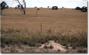
Gently undulating sand plain in the Propodollah area.
Soil Types
Two general soils are found within this land system; Deep Sandy Sodosols (Site LS14) and Yellow and Red Sodosols with shallower loamy sand or sand surfaces (Sites LS12 and Site LS14A). In areas with shallow horizons of unconsolidated surface sand, the soils are typically mottled Yellow or Brown Sodosols but Red Sodosols may also occur. Surface sand or loamy sand horizons are usually less than 20 cm in depth and are slightly acid. The top of the subsoil is generally a mottled dense sandy clay with development of coarse columnar structure and a hard bleached capping (Great Soil Group is solodized solonetz). The top of the subsoil is usually strongly sodic and moderately alkaline and becomes very strongly alkaline with depth. Zones of soft carbonate accumulation occur also at depth.
In the large mapped unit adjacent to the southern edge of the Big Desert (e.g. Site LS17), the surface horizons in areas with shallow unconsolidated sand are typically slightly to moderately alkaline. Subsoils are strongly alkaline and become extremely alkaline with depth. The top of the subsoil is a strongly sodic dense sandy clay loam or sandy clay with development of coarse columnar structure and a hard cemented bleached capping. A bleached fine sand A2 horizon may also occur above this. Colours at the top of the subsoil are usually yellowish brown and/or brownish yellow. On level areas soils with moderately alkaline sandy loam surface horizons can also occur.
In areas with deep unconsolidated siliceous sand (Lowan Sand), soils can be described as deep sandy Sodosols. If unconsolidated sand is greater than 1 m in depth the soil can be classified as Arenic Rudosols or Tenosols (Great Soil Group is a siliceous sand) depending on soil profile development. Rudosols are young sands which display weak pedalogical organisation apart from the minimal development of a A1 horizon. Tenosols will show more development, having either a more than weakly developed A1 horizon, an A2 horizon or a weakly developed B horizon (with a clay percentage of <15%). The surface horizon is typically a slightly acid loamy sand which is dark brown in colour due to organic matter accumulation. Subsurface horizons are mainly slightly acid bleached sands. If a consolidated subsoil horizon occurs it would typically be sodic and have a clay percentage of over 15%. It would also show some development of coarse columnar structure with a hard bleached capping (Great Soil Group is a soloth) if the B horizon is acid.
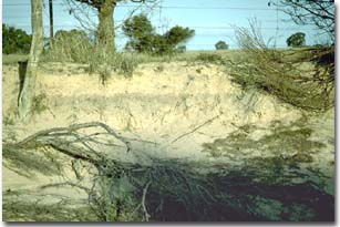 A road cutting through a dune on a gently undulating sand plain south of Netherby. Note: the deep siliceous sand (Lowan Sand) profile which would be classified as an Arenic Rudosol (i.e. rudimentary soil development). |
Back to top
Yellow and Red Sodosols (sandy surfaces)
© State of Victoria (Agriculture Victoria) 1996 - 2025.

This work, Victorian Resources Online, is licensed under a Creative Commons Attribution 4.0 licence. You are free to re-use the work under that licence, on the condition that you credit the State of Victoria (Agriculture Victoria) as author, indicate if changes were made and comply with the other licence terms.
The licence does not apply to ‘branding’ or some ‘images or photographs’ that may be owned by third parties. We ask you to seek prior approval to use images using the VRO feedback form. Access to higher quality images can also be provided on request.
This page was last updated on 25/01/2019.