
Gently Undulating Rises
Desciption of the Land System
Landform and Distribution
This unit consists of Gently Undulating Rises which are generally aligned in a NNW / SSE direction. Slopes are generally 2-3% and the relative relief varies between 10-30 m. These rises are broader and usually have greater relief than the low rises which occur as part of the Gently Undulating Plains unit. The parent material of most of these rises is sandstone (referred to as Parilla Sand on geological maps) which can occur within 1 m of the soil surface. Deposits of calcareous clay mobilised by wind have also occurred.
Native Vegetation
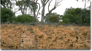 A road cutting across part of a Gently Undulating Rises unit near Kiata. Note the Parilla sandstone and the relatively shallow depth of soil on top. Yellow Gum is the dominant eucalypt. |
Yellow Gum (Eucalyptus leucoxylon) occurs on many of the rises, particularly in areas with lighter textured surface soils. It may occur in association with Grey Box (Eucalyptus microcarpa).
Mallee vegetation occurs on some of the rises in the lower rainfall area to the north of the District and where deep sands occur.
Soil Types
There appears to be quite a variation in soil types on Gently Undulating Rises units throughout the district. Also, there is evidence that differences in soil development have occurred on eastern versus western sides of some rises due to wind deposition.
Rises sampled in the Woorak area have displayed soil differences related to aspect. On the midslope of the western side of a Rise at Woorak the soil is a Red Sodosol with a heavy sandy clay loam surface which has a neutral pH (Site LS19). The subsoil begins at 15 cm depth and is an alkaline reddish brown heavy clay with strongly developed prismatic structure. With depth, the clay becomes paler, more alkaline and contains a moderate amount of soft carbonate. The soil exhibits vertic properties at almost 2 m depth. In the Great Soil Group Classification this would be a sodic red-brown earth. On the eastern side the soil is also a Red Sodosol (Site LS23) but differs in that surface horizons have a loamy sand texture. The subsoil also differs, having a weak coarse columnar structure which has a hard bleached capping. The subsoil clay is yellowish red in colour and contains a zone of carbonate accumulation. Weathered sandstone occurs at 1 m in depth. The Great Soil Group for this soil is a solonetz.
On a subdued north-south trending rise near Netherby, the soils are Red Sodosols with slightly alkaline surface horizons overlying a strongly sodic reddish brown subsoil which becomes paler in colour and very strongly alkaline with depth. At the crest of the rise, weathered sandstone occurs at about 1.5 m depth. Surface soil texture on the western side of the rise is a sandy clay loam (Site LS15). On the eastern side of the rise, the surface soil texture is lighter, i.e. sandy loam (Site LS15A). These surface soil texture differences on either side of the rise probably relate to the nature of the windblown deposition.
Soils on Rises in the Kinimakatka and Winiam areas do not seem to show distinct differences in surface soil texture in relation to aspect. These soils are generally Red Sodosols with clay loam surface soils. There is some evidence that surface soil pH varies depending on slope position. At Winiam, surface soils on upper slopes (Site LS1) are slightly to moderately acid and become slightly acid to slightly alkaline on lower slopes. Furthermore, on lower slopes (Site LS2) subsoils exhibit vertic properties (i.e. lenticular structure) at depths greater than 1m. These soils with vertic properties at depth seem to be an intergrade to the Grey Vertosols on the adjacent flats.
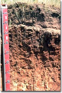
 A road cutting in the Winiam area on a gently undulating rise. Note: the presence of a Red Sodosol on the upper slopes and a Brown Sodosol on the mid slopes |
Red Sodosols and Grey Sodosols (Site LS9) have been noted on rises in the Yanac region. The surface soils are usually sandy clay loam in texture and are moderately alkaline. However, in some areas they may be sandy to sandy loam in texture. Subsoils are generally sodic to strongly sodic and coarse prismatic in structure. There is evidence that vertic properties exist in deeper subsoils on lower to middle slopes.
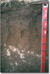
 Gently Undulating Rises unit at Winiam. Note: Black Box vegetation and grey clay surface horizon (Grey Vertosol) in foreground and Yellow Gum and brown surface horizons (Red and Brown Sodosols) on rise. |
Example Soil Profiles:
Red Sodosol (on an upper slope of a rise at Kinimakatka)
 | Surface Soil | ||
| A1 | 0-10 cm | Dark brown; sandy clay loam; pH 6.0: | |
| A2 | 10-15 cm | Brown; sandy clay loam; strong consistence; pH 6.5: | |
| Subsoil | |||
| B21 | 15-25 cm | Reddish brown; heavy clay; strongly developed coarse prismatic structure; very strong consistence; pH 7.3: | |
| B22 | 25-60 cm | Yellowish red; mottled; heavy clay; very coarse prismatic structure; pH 9.2: | |
| B23 | 60-100 cm | Yellowish brown; medium heavy clay; soft and nodular calcium carbonate present (10-20%); pH 9.4. | |
Red Sodosol - sandy surface (on eastern slope of a rise near Woorak)
 | Surface Soil | ||
| A1 | 0-15 cm | Dark reddish brown; loamy sand; pH 7.1: | |
| A12 | 15-25 cm | Dark reddish brown; sand: | |
| Subsoil | |||
| B21 | 25-50 cm | Yellowish red; medium clay; weakly developed coarse columnar structure, parting to moderately developed medium prismatic structure; hard bleached capping; very firm consistence; pH 8.6: | |
| B22 | 50-80 cm | Yellowish red; mottled; heavy clay; very coarse prismatic structure; pH 9.2: | |
| B23 | 80-100 cm | Yellowish red; medium clay; soft calcium carbonate present; pH 9.4: | |
| C | 100 cm+ | Weathered sandstone. | |
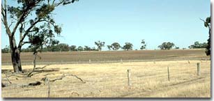
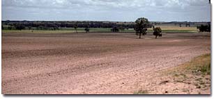 View from the top of a Gently Undulating Rises unit near Balrootan North looking westwards to the Propodollah Ridge (Undulating Low Hills unit) in the background. Between these units is the Grey Clay Plains unit. Note: the presence of the sandy surface horizon in the foreground. |
Soil Characteristics and Management Options
© State of Victoria (Agriculture Victoria) 1996 - 2025.

This work, Victorian Resources Online, is licensed under a Creative Commons Attribution 4.0 licence. You are free to re-use the work under that licence, on the condition that you credit the State of Victoria (Agriculture Victoria) as author, indicate if changes were made and comply with the other licence terms.
The licence does not apply to ‘branding’ or some ‘images or photographs’ that may be owned by third parties. We ask you to seek prior approval to use images using the VRO feedback form. Access to higher quality images can also be provided on request.
This page was last updated on 25/01/2019.