
G4
| Location: Rosedale. | Australian Soil Classification: Haplic, Eutrophic, Brown KANDOSOL |
| Geology: Recent sediments. | General Landscape Description: Flood plain of the La Trobe River. |
| Mapping Unit: La Trobe River. | Site Description: Soil auger site within a grazing paddock. |
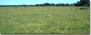 Site GP4 Landscape |
Soil Profile Morphology:
Surface Soil
| A1 | 0-30 cm | Dark brown (10YR3/3); very fine sandy clay loam; weak fine polyhedral structure; weak to firm consistence dry; pH 5.8; diffuse change to: | |
| Subsoil | |||
| B21 | 30-60 cm | Brown (10YR4/3); very fine sandy clay loam; diffuse change to: | |
| B22 | 60-90+ cm | Brown (10YR4/3) with strong brown (7.5YR5/6) mottles, very fine sandy clay loam, weak medium polyhedral structure; firm consistence moist; many macropores present; pH 5.8. | |
Key Profile Features:
- Lack of texture contrast throughout the soil profile.
Soil Profile Characteristics:
Horizon | pH | Salinity Rating | ||
Surface (A1 horizon) | Moderately Acid | Very Low | Non-Sodic | none |
Subsoil (B21 horizon) | Moderately Acid | Very Low | Non-Sodic | none |
Deeper subsoil (at 90 cm) | Moderately Acid | Very Low | Non-Sodic | none |
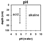 | The soil profile is moderately acid throughout. | 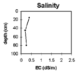 | The salinity rating is very low throughout the soil profile. |
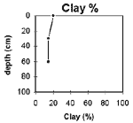 | The clay content is fairly uniform throughout the soil profile. |
Soil auger site G4 (Sargeant and Imhof, 2000)
Depth cm | Texture | pH | EC 1:5 | Nitrogen % | Carbon % | Ca meq% | Mg meq% | K meq% | Na meq% | H meq% | Coarse sand % | Fine sand % | Silt % | Clay % | LAT % |
0-30 | FSCL | 5.8 | 0.2 | 0.18 | 3.8 | 3.5 | 3.4 | 0.1 | 0.5 | 8.5 | 2 | 46 | 21 | 27 | 1 |
30-60 | FSCL | 5.8 | 0.06 | 2.0 | 2.1 | <0.1 | 0.2 | 7.2 | 2 | 55 | 23 | 20 | 1 | ||
60-90 | FSCL | 5.8 | 0.07 | 1.7 | 2.2 | <0.1 | 0.2 | 7.1 | 2 | 55 | 23 | 20 | 1 |
The following abbreviation was used to describe field texture: FSCL - fine sandy clay loam.
Other symbols include: pH - analysed in water; EC - electrical conductivity; Cl - chloride; Ca - exchangeable calcium; Mg - exchangeable magnesium, K - exchangeable potassium; Na - exchangeable sodium; H - exchangeable hydrogen; ESP - exchangeable sodium percentage.
For Soil Pit Sites (Sargeant and Imhof, 2000) exchangeable cations have been determined using Gilman method (where pH >7) and Tucker method (pH <7). Exchangeable Sodium % (ESP) has been calculated here as the percentage of sodium in relation to the sum of the exchangeable basic cations.
Management Considerations:
Whole Profile
- Plant Available Water Capacity (PAWC) is considered to be moderate (estimated at 110 mm) for this soil profile. This is based on an estimated effective rooting depth of 60 cm, although there are not likely to be restrictions below this depth for more deeply rooted species. PAWC has been estimated using a model developed by Littleboy (1995) which uses analytical data for clay %, silt %, fine sand %, coarse sand % and wilting point.
- Water and root movement is not likely to be significantly restricted in this soil profile.
Profile Described By: Mark Imhof and Ian Sargeant.
© State of Victoria (Agriculture Victoria) 1996 - .

This work, Victorian Resources Online, is licensed under a Creative Commons Attribution 4.0 licence. You are free to re-use the work under that licence, on the condition that you credit the State of Victoria (Agriculture Victoria) as author, indicate if changes were made and comply with the other licence terms.
The licence does not apply to ‘branding’ or some ‘images or photographs’ that may be owned by third parties. We ask you to seek prior approval to use images using the VRO feedback form. Access to higher quality images can also be provided on request.
This page was last updated on .