
Crooke (Ck)
| Geology Quaternary (Late Pleistocene) alluvium. Landform Alluvial terrace - an earlier flood plain of the La Trobe River. |  |  |
It is likely that this map unit carried little vegetation and was predominantly grassland. However, there is occasional red gum (Eucalyptus tereticornis).
Previous Maps and Reports
This map unit is included within the Valencia Land System as described by Aldrick et al. (1992). Drake and Poutsma (1956) mapped the soil as Crookes clay.
Soils
Crookes clay is the main soil type on the higher flood plain. The soil is often crabholey or “buckety” (gilgai) and its external drainage is poor in many places. It cracks when dry and areas are likely to be saline. The soil is a very dark grey or black medium to heavy clay becoming slightly paler in colour with depth. Occasionally the surface soil is a shallow clay loam. The soils which are clayey throughout are generally classified as Grey or Black Vertosols.
Chemical and Physical Analysis
An analysis of the soil to 1 metre is given for an auger site below.
La Trobe Valley - Soil Auger Site G3 (Sargeant & Imhof, 2000).
Depth cm | Texture | pH | EC dS/m | Cl % | Nitrogen % | Carbon % | Ca meq% | Mg meq% | K meq% | Na meq% | H meq% | ESP % | Gravel % | Coarse sand % | Fine sand % | Silt % | Clay % | LAT % |
0-20 | LC | 6.3 | 0.66 | 0.11 | 0.21 | 2.8 | 4.2 | 8.8 | 0.2 | 2.2 | 7.2 | 10 | 10 | 24 | 21 | 41 | 2 | |
20-50 | MHC | 5.9 | 1.7 | 0.38 | 2.9 | 7.9 | 0.2 | 2.9 | 7.3 | 14 | 6 | 21 | 21 | 49 | 2 | |||
50-85 | MHC | 6.9 | 2.4 | 0.42 | 3.2 | 9.9 | 0.2 | 4.0 | 4.8 | 18 | 5 | 16 | 20 | 57 | 1 | |||
85-100 | MHC | 7.2 | 2.2 | 0.10 | 3.3 | 12 | 0.4 | 7.9 | 33 |
Other symbols include: pH - analysed in water; EC - electrical conductivity; Cl - chloride; Ca - exchangeable calcium; Mg - exchangeable magnesium, K - exchangeable potassium; Na - exchangeable sodium; H - exchangeable hydrogen; ESP - exchangeable sodium percentage.
For Soil Auger Sites (Sargeant and Imhof, 2000) exchangeable cations have been determined using Gilman method (where pH >7) and Tucker method (pH <7). Exchangeable Sodium % (ESP) has been calculated here as the percentage of sodium in relation to the sum of the exchangeable basic cations.
Land Use
Grazing of sheep and cattle is generally carried out on this map unit. These soils are too clayey to have any horticultural potential.
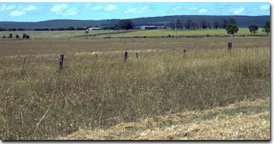 Vertosols occur in the foreground on the Crooke mapping unit near Rosedale. Note the terrace (Loy Yang mapping unit) in the middle ground and the hills in the background (Stockdale/Gormandale mapping units). These were formed by uplift along the Rosedale fault. |
|
© State of Victoria (Agriculture Victoria) 1996 - 2025.

This work, Victorian Resources Online, is licensed under a Creative Commons Attribution 4.0 licence. You are free to re-use the work under that licence, on the condition that you credit the State of Victoria (Agriculture Victoria) as author, indicate if changes were made and comply with the other licence terms.
The licence does not apply to ‘branding’ or some ‘images or photographs’ that may be owned by third parties. We ask you to seek prior approval to use images using the VRO feedback form. Access to higher quality images can also be provided on request.
This page was last updated on 25/01/2019.