
Soils of the Maffra Region
|
Soils of the Maffra Region A-Z | Geology and Geomorphology | References |
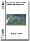
| This information has been obtained from the Major Agricultural Soils of the Maffra Region survey and report by Sargeant and Imhof (2000). This covers an area of approximately 250 000 hectares, comprising the flood plains and surrounding lands of the lower reaches of the Latrobe, Macalister and Avon rivers. Land use in the area is influenced by the soil type and availability of irrigation water. The elevated areas are predominantly mixed dryland farming (beef, sheep, and some winter cropping) with forestry on the upper slopes. The river flood plains and terraces are used for intensive irrigated agriculture (predominantly dairy grazing and some vegetable cropping on the better soil types). |
 |
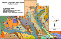
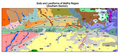
These maps were developed for the report: 'Major Agricultural Soils of the Maffra Region' by Sargeant and Imhof (2000). These maps were originally prepared at a scale of 1: 50 000. | |
Soil survey information provides a framework for assessing soil management across the study area. The current survey identifies the presence and location of soil limitations that could potentially affect the viability of specific land uses. Soil depth, permeability and sodicity are three soil characteristics of particular importance for the Macalister Irrigation District (MID) - comprising an area of some 54 000 hectares within the current study area. The intensive irrigated enterprises (e.g. dairying) found in the MID need accurate soil information on which to base irrigation investment decisions. In addition, the broader community is increasingly demanding greater accountability by the irrigation industry for the efficient use of water and to minimise off-site impacts such as phosphorus transfer to the region’s rivers and lakes. This study provides some of the key soil information required by land managers and agencies to design and implement farm irrigation systems and practices to balance individual and community aspirations.
Small areas within this current survey have previously been mapped by Skene and Walbran (1948, 49) in great detail (scale of 1: 31 680). The current mapped area also fits within a broader land survey by Aldrick et al (1992) at a published mapscale of 1:250 000. The eastern part of the current survey has also been covered previously by the broadscale survey of Ward (1977) with a mapping scale also at 1:250 000.
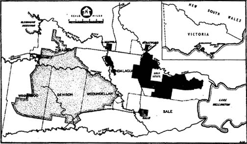
Extent of previous surveys by Skene and Walbran (1948,49).
This survey is based on the concept of “soil landscapes” which are areas of land that “have recognisable and specifiable topographies and soils, that are capable of presentation on maps, and can be described by concise statements” (Northcote, 1978). However, rather than using the word “soil landscapes” the word “mapping units” is used as it is more flexible and has a less precise definition. The mapping units are described in terms of geology and landform, and the range of soils occurring within each mapping unit is described.
Each of the mapping units is given a name, which is generally based on the name first given to the major soil type, soil association or land system by previous authors. On the map it is generally represented by a two-letter code. The boundaries between the mapping units were drawn onto aerial photographs (approximate scale 1: 50 000) and then transferred to topographical maps at scale 1: 25 000 for digitisation. The map is presented at a scale of 1: 100 000 and should not be extrapolated to a larger scale.
About 400 sites exposed by soil auger were described outside of the area covered by Skene and Walbran. These descriptions were then used to describe the range of soil properties within each of the mapping units. Detailed physical and chemical data from 82 sites are also provided. These sites include 30 soil pit sites examined during this survey and presented here.
Apart from the detailed mapping by Skene and Walbran (1948,49) in the 1940’s, most of the area was relatively poorly understood in terms of the range of soils present. This work brings together all of the previous work under a consistent geomorphological framework designed for all of Victoria and classifies the soils according to the Australian Soil Classification (Isbell, 1996). The terminology used here is also consistent with that described in the Australian Soil and Land Survey Handbook (McDonald et al., 1990). Previous map unit names have been retained where appropriate, following the convention of using the name first used to define the map unit.
Acknowledgments
The soil survey of this region has been funded by the Victorian Government’s Agriculture and Food Initiative and has been developed as part of the Victorian Resource Atlas project.
The main contributors to the development of this report are:
| Field Survey and mapping: | Ian Sargeant |
| Soil Site Assessment: | Ian Sargeant, Mark Imhof, David Rees |
| Text: | Ian Sargeant, Mark Imhof |
| Soil Site Formatting: | Sonia Thompson, Angela Murphy |
| Formatting and image scanning: | Angela Murphy |
| Soil Analysis: | DPI's State Chemistry Laboratory |
| Image Map development: | Kathleen Hirst. |
Simon Hunt (Pivot Fertilisers) and Len Rule (the former NRE, Maffra) assisted in site selection for soil pits. Debbi DeLaney (the former NRE, Traralgon) assisted in site selection of soil pits in the Traralgon region. Field Days associated with this report have been organised by Gavan Lamb (the former NRE, Maffra). Gavan has also contributed by reviewing drafts of this report and providing valuable feedback.
Soil Pit Field Days were held in the region by the former DNRE, Maffra during 21-22 May, 2001.
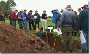
Landholders and regional staff at a Soil Pit Field Day during May, 2001.
Related VRO Reports
A Study of the Land in the Catchment of Gippsland Lakes - Volume 2
© State of Victoria (Agriculture Victoria) 1996 - 2025.

This work, Victorian Resources Online, is licensed under a Creative Commons Attribution 4.0 licence. You are free to re-use the work under that licence, on the condition that you credit the State of Victoria (Agriculture Victoria) as author, indicate if changes were made and comply with the other licence terms.
The licence does not apply to ‘branding’ or some ‘images or photographs’ that may be owned by third parties. We ask you to seek prior approval to use images using the VRO feedback form. Access to higher quality images can also be provided on request.
This page was last updated on 24/05/2019.