
Moe Mapsheet
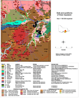
The soils and landforms of the Moe 1:100 000 mapsheet were mapped by Ian Sargeant and described by Ian Sargeant and Mark Imhof during 1996/97. This work was supported by the National Landcare Program.
| Information on the soil/landscape units mapped can be obtained by clicking the map legend. Mapping was carried out at a 1:100 000 scale which necessitated some generalisation. Users should exercise caution when interpreting map information as it presents a guide only as to the likely soil types in an area. In any one area soils can vary significantly according to landscape, geology and management. Any agricultural enterprise should be based on a detailed on-site assessment of the soil and landscape. | To view the information PDF requires the use of a PDF reader. This can be installed for free from the Adobe website (external link). |
© State of Victoria (Agriculture Victoria) 1996 - 2025.

This work, Victorian Resources Online, is licensed under a Creative Commons Attribution 4.0 licence. You are free to re-use the work under that licence, on the condition that you credit the State of Victoria (Agriculture Victoria) as author, indicate if changes were made and comply with the other licence terms.
The licence does not apply to ‘branding’ or some ‘images or photographs’ that may be owned by third parties. We ask you to seek prior approval to use images using the VRO feedback form. Access to higher quality images can also be provided on request.
This page was last updated on 25/01/2019.