
Salinity in the Loddon Murray Region
Salinity Indicator Plants Home | Soil-salinity Tolerant Plants - Loddon Murray Region | Salt-sensitive Wetland Plants - Loddon Murray Region | Related Links
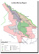 Loddon Murray Region Map | The Loddon Murray Region straddles the boundary between the Central and Northern Victorian Region and the Mallee Region of the Salinity Indicator Plants guide and therefore draws in elements of both those regions. It is addressed here in greater detail than the broader regions of this guide as it has been very active in addressing the problems caused by high watertables and salinity through the development and implementation of Land & Water Management Plans. Landuse This 650 000 ha area contains a diverse range of farming enterprises. Over half the area is irrigated consisting of mixed cropping and grazing (260 000 ha), dairying, (83 000 ha) and horticulture (7 000 ha). Approximately 1 million megalitres of irrigation water is applied to this area, the majority via flood irrigation. Irrigation water is applied more intensively in the dairy farming areas surrounding Cohuna and Leitchville. Mixed grazing and cropping enterprises are spread throughout the region in a mosaic pattern and generally receive less intensive irrigation. The Mallee strip on the western side of the Loddon Murray Area is largely broad acre cropping and grazing farmland. Horticulture occurs in smaller areas predominantly along the mallee fringe around Boort, Tresco, Swan Hill and Nyah. |
Native Vegetation on the Floodplain
The region supports a rich range of flora & fauna including Black Box & Red Gum forests on the floodplain. Regular flooding has resulted in the deposition of a thick layer of clays and silts across the floodplain and this combined with the availability of flood water has largely determined the vegetation communities present on the flood plain. There are numerous large wetlands in the northern (lower) end of the catchment.
Native Vegetation in the Mallee
Mallee Eucalypts, wattles and understorey plant communities occur in the west of the area. The majority of the native vegetation has been cleared for agriculture and most of the main native plant communities have been reduced to less than 15 % of their original distribution. The Avoca River and several major breakaway creeks occur in this area and Red Gum and Black Box plant communities replace the mallee plant communities in these wetter drainage lines.
Floodplain Soils
The soils on the floodplain or irrigated areas of this region are variable however they are dominated by medium to heavy clays that become heavier at depth (Vertosols). The area is fairly flat and generally the land falls gently to the north.
The numerous wetlands in the northern region were formed thousands of years ago by soil being blown out of wetland depressions after a dry phase. Over time this process deepened and enlarged the wetlands, depositing the clay particles on the eastern and northeastern sides of the wetland and formed elevated areas (lunettes).
Mallee Soils
The Mallee dryland area extends westward from the floodplain. This area contains a variety of soil types (derived from windblown material) - however, the area is dominated by Calcarosols (with sandy loam to loam surface soils) that are much lighter in texture than those on the floodplain.
See the Mallee VRO website for further information on Mallee soils.
Groundwater Levels beneath the Floodplain
A shallow, saline regional groundwater system underlies much of the Loddon floodplain and is the primary cause of soil salinisation in this area. Groundwater levels are variable but generally higher in the north, towards the lower end of the catchment. In a typical year at least 35% of the floodplain can have groundwater levels within 2 m of the surface.
The salinity of the regional groundwater is typically about 50 000µ S cm-1 (compared to seawater which has an EC value of being 50 000µ S cm-1). Due to the heavy impermeable nature of the soils, groundwater movement is slow and tends to be in a north and northwesterly direction.
Saline soils occur in areas of high, saline watertables. These areas are scattered throughout the irrigated area however they are more common in the north & central areas. Approximately 16% of the irrigated area on the Loddon Floodplain is severely affected by salinity (Ranges S3 & S4).
Groundwater Influences in the Loddon Floodplain
The northern Loddon Plain is a natural groundwater discharge zone and natural salt lakes occur at the lower end of the catchment. However the water balance has been dramatically altered since European settlement and this has resulted in significant increases in groundwater levels and the area of saline soils.
The clearing of the upper central highlands has resulted in additional water entering the groundwater system, which then flows into and pressurises the deeper groundwater systems beneath the Loddon floodplain. These deeper groundwater systems are under pressure and prevent the downward movement of local surface water (rainfall and flooding) from percolating into the underlying soil layers and groundwater systems, resulting in elevated groundwater levels.
In addition native vegetation was also cleared from the floodplain increasing local accessions to the watertable even though the area has a relatively low annual rainfall of 400 mm. Accessions to the watertable also occur from flooding, flood irrigation and the associated irrigation channels and storages.
Groundwater Influences in the Mallee
Groundwater levels are significantly lower under the Mallee in the west of the region than under the adjacent Loddon Floodplain. The regional groundwater system is generally at least 20 m below the soil surface under the majority of the Mallee area and appears stable.
There are small isolated pockets of saline soils where groundwater levels are close to the surface, however, they only occupy a very small percentage of the total Mallee area. Some of these pockets suffer from a “perched watertable” where rainfall leaches beyond the root zone of plants and cannot infiltrate through a hard impermeable layer. This has the effect of creating a ground water mound, which may lead to the formation of saline areas above the valley floor.
The Avoca River and several breakaway creeks occur in the Mallee in the west of the Loddon Murray area. The Avoca River is largely unregulated and floodwater recharges the groundwater system during flood events however it has little effect on the regional groundwater system.
Indicators of Salinity
There are several visual indicators that can be used to identify saline soils. For example, the vegetation community, surface moisture, bare ground, salt crystals and the position in the landscape. Recognising several of these indicators at a site increases the accuracy of a visual assessment.
Visual assessments can identify saline areas but soil sampling and EM 38 (Electro Magnetic Readings) readings will provide a more accurate indication. Soil sampling should be used with caution as soil salinity levels can vary considerably over a short distance both horizontally and at depth. It should also be recognised that soil salinity levels can vary significantly seasonally and are often lowest after winter leaching rains.
When assessing the effect of soil salinity on agriculral production, attention should to be paid to the salinity of the soil within the plant root zone.
In the Loddon Murray area, low-lying areas are generally more susceptible to salinisation as watertables are likely to be closer to the surface than in areas higher in the landscape.
Vegetation Indicators
The most common criterion for recognising salinity is the presence of known salt tolerant plants and the absence of known salt sensitive plants.
It should also be recognised that the poor growth of agricultural crops and pastures could be caused factors other than salinity (e.g. moisture stress, insufficient nutrients).
In saline areas it is common to find a number of salt tolerant species forming a plant community and their distribution often reflects the mosaic and variable nature of the saline soils.
Salt tolerant plants are able to grow in saline soils, each species capable of surviving on range of salinities. It is difficult to nominate the exact salinity range for each plant as this is influenced by several other factors such as soil type, waterlogging, grazing, and competition from other plants.
The presence of 2 or 3 known salt tolerant plants and a reduction in number, or total absence of salt sensitive species common in adjacent non-saline areas, combined with other visual indicators such as position in the landscape or the presence of bare salt scalds generally confirms the soil is saline.
Plants can also survive at higher soil salinities on lighter textured soils, which are often better drained.
The diversity of plants capable of growing in an area decreases as soil salinity increases. At extremely high soil salinities only a small number of plants are capable of surviving. Plants may change colour or alter their form as soil salinity levels increase.
Related Links
© State of Victoria (Agriculture Victoria) 1996 - 2025.

This work, Victorian Resources Online, is licensed under a Creative Commons Attribution 4.0 licence. You are free to re-use the work under that licence, on the condition that you credit the State of Victoria (Agriculture Victoria) as author, indicate if changes were made and comply with the other licence terms.
The licence does not apply to ‘branding’ or some ‘images or photographs’ that may be owned by third parties. We ask you to seek prior approval to use images using the VRO feedback form. Access to higher quality images can also be provided on request.
This page was last updated on 23/03/2020.