
8 Priorities for soil health
Back to: Soil health for Victoria's agriculture - context, terminology and concepts
8.1 Representation: data needs and data management | 8.2 Processes: understanding of soil processes | 8.3 Evaluation: methods for evaluation of soil health | 8.4 Change: land management and land use scenarios | 8.5 Impacts: understanding and predicting impacts on soil health | 8.6 Decisions: support for soil health management | 8.7 Decision making and knowledge of soil change | 8.8 Theory of action for knowledge delivery in the ESAS health soils project
Priorities for soil health depend on the stakeholder and area of concern (Section 7.4). DPI Agriculture Division have prepared a theory of action for soil health after consultation through workshops for the soil health policy framework (DPI 2006). This sets the high level objectives, theoretical process and accountability for soil health. The discussion that follows in this section is more focussed on the science requirements to support a soil health program and is structured around the six thematic questions of the Steinitz framework (Section 7.1).
8.1 Representation: data needs and data management
Analysis of the soils data available through the Victorian Soil Sites Database (VSSD) and GIS layers held by DPI PIRVic has provided some insight into soil quality variability across soil groups (Crawford et al. 2006). However, there is a paucity of sites entered into the database compared to the total of Victorian sites documented in reports. It should be a priority to enter relevant site data into the VSSD wherever they can supplement the existing dataset with useful reference data. There are several soil parameters that are unavailable or have only limited availability, particularly quantitative physical properties important for understanding and modelling soil hydrology. Crawford et al. (2006) have made several recommendations for the improvement in soil data. The ‘Datatrack’ project funded by DPI from July 2006 will serve to identify the required business processes and accountabilities to address these needs. Appendix C has outlined the case with respect to biological data for which there is currently no database. Given the high level of interest by the farming community in soil biology, meeting the data requirements in this area is also a priority.
The spatial extent or coverage of soil data is limited to coarse scale (1:250,000 land systems) for the whole state. At this scale only the broadest indication of soil type can be given. Some regions have soil–landform maps at 1:100,000 scale, but because of soil variability within the map units, these too are limited and have little application at farm or paddock level. These issues are discussed more fully in Crawford et al. (2006) but it is worth emphasising here that a full inventory of soils and properties is a necessary basis for any advisory work or soil–correlation for agricultural research and extension. Mapping also needs to be at a resolution appropriate to modelling needs but this is a point that is invariably overlooked by the end users of model outputs. The work that has been carried out in revising land systems in the new Victorian Geomorphological Framework is a significant step in working towards an integrated multi–scale mapping approach for soil and land in Victoria. This work will need to be continued through soil correlation from older surveys and augmentation with new land resource surveys and site data.
Data access is limited by the lack of a user–friendly, web–based interface to the VSSD but this is being addressed through the newly funded soil health project (ESAS and LWA MIS 03250) which will commission the database scripting work As well as access to data, there is a generally limited understanding in DPI concerning what data are available and where they can be obtained. This also applies to map data. This general problem of access to, and knowledge of, data and modelling requirements has been tackled in part under the ORL project ‘Our Landscape’ through the MIKE conceptual tool (Models, Information and Knowledge Environment) but needs to be continued through other initiatives.
Soil data that have been collected in the past have either been collected as part of mapping programs or have been related to particular soil management or comparison objectives in research projects. The VSSD has not in the past been able to accommodate time series data records for monitoring at a site, though recent redesign of the VSSD by the Spatial Sciences subplatform of DPI for the Victorian Earth Information System (VEIS) may address this issue. There is no history of systematic data collection for soil quality or soil health attributes per se, so the need for this needs serious consideration. The Healthy Soils for Sustainable Farms project (Land and Water Australia, MIS 03250) has an objective centred on the use of paired sites for comparison and demonstration of soil management. Soil monitoring at these sites will require a system for data collection, storage and analysis.
8.2 Processes: understanding of soil processes
There is a broad body of literature on soil processes that can be used to inform understanding in this area. Application of the general understanding to specific soils and management situations is restricted both by the limited locally focussed research and the knowledge (training) base of staff in DPI for basic soil science. Specialists in the department can be called on to interpret specific situations but without hard data, much of this interpretation remains in the realm of educated guess work. There are many questions raised in the farming community as well as in the science community concerning the relationships between crop production and the soil system. In a broader context there are questions concerning the relationship between actions at a paddock scale and interaction with processes at a catchment (e.g. groundwater, nutrient movement) or even global (greenhouse gases, carbon sequestration) scale. These broader scale questions generate their own data needs related to landscape structure and conceptual models that link soil to groundwater systems, and climate models that link land use management to global atmospheric systems.
Soil biological processes consistently emerge as a major area for advice that can only be given in a very general way. The growing interest in ‘biological’ farming is a significant external driver for research that can provide scientifically defensible advice for the management of soil biology in crops and pastures. There is also limited readily available understanding of processes in the rhizosphere (the soil environment immediately related to root growth and root–soil interactions) although a recent publication (Zobel and Wright 2005) has brought together a lot of knowledge on this topic. Most soil analyses and interpretations are made on the basis of samples of soil that are bulked in order to represent the whole soil horizon of interest. However, the properties (biological, physical and chemical) of the rhizosphere are very different to those of the bulk soil matrix (Whalley et al. 2005; Gregory 2006). Rhizosphere studies are needed in order to provide better interpretation of soil quality attributes and the relationship between soil health and plant growth.
8.3 Evaluation: methods for evaluation of soil health
Probably the greatest limitation to assessment of how well the soil system is working is the lack of basic data on soil and land condition and the minimal application of monitoring tools. At the paddock scale this can be effectively addressed by individual landholders, provided soil variability is taken into account. Soil health scoring systems can be devised based on quantitative and qualitative assessments of soil function.
However, recommendations for appropriate indicators and methods are currently not available from DPI and in some instances (e.g. biology) are challenged by the lack of useable indicators. The DPI Healthy Soil project commencing this year (2006) will review, recommend and trial tools for soil health assessment with participating farmer groups so the need for paddock scale evaluation of soil health will be addressed.
Soil assessment at one time gives an indication of how well the soil can perform its required functions at that time, but serial assessment over several seasons is need in order to provide trend data that would indicate how well the system is working. McKenzie, Henderson and McDonald (2002) have proposed methods for soil monitoring but these have not been applied in Victoria. There is potential through the Healthy Soils project to test the feasibility of setting up Victorian reference sites for long term monitoring in key agricultural landscapes.
At regional, state and national levels there are requirements to report on the state of the environment and in particular on land and soil condition. Baseline data were provided for the National Land and Water Resources Audit based on available information or interpretation by the States at that time (2000). General recommendations were made nationally that soil condition should be monitored for acidification, organic carbon, wind erosion and water erosion. Recent work commissioned by the Audit office through the National Committee for Soil and Terrain has resulted in recommendations from working groups for each of these indicators (McKenzie and Dixon 2006). In Victoria several CMAs have developed, or are developing, soil health strategies with resource condition targets (RCTs) and management action targets (MATs) but these strategies have had insufficient baseline data and little information to guide the setting of targets. There is therefore a strong need for regionally based assessment methods to enable reporting on soil and land condition. The Agriculture Division’s ‘Triple Bottom Line Indicators’ project is currently reviewing approaches to this problem, and the DSE have also expressed intentions to develop a “Land Health Index” that would incorporate soil health.
In the absence of hard data on soil condition it is still possible to evaluate how well the system is working. Land use and land management (land use practices) have been used at the regional level to model the likelihood of a range of threats to soil health. Relationships between land use management and soil susceptibility (based on soil landform descriptions) have been incorporated in the Land Use Impact Model (LUIM) to develop a soil health strategy for the Corangamite region (MacEwan, McNeill and Clarkson 2004). The LUIM approach is useful for identifying areas that are likely hotspots based on the threats posed by land use management (McNeill and MacEwan 2007). This is a good surrogate for monitoring soil condition, provided the relationships are sound and spatial information on land use can be updated. A similar approach is being advocated in Europe in a report by Eckelmann et al. (2006) which presents an overview of common criteria and approaches to identify risk areas for soil organic matter decline, soil erosion, soil compaction, salinization and landslides.
Direct monitoring of soil condition may be prohibitive at a regional scale simply because of the diversity7 of combinations that can occur between soils, landscapes and agricultural practices. If this is the case and we continue to rely on surrogates and assumptions concerning best management of land, then it is a priority to test these assumptions in order to provide more confidence in the modelling. This could be carried out across Victorian agricultural landscapes using a series of reference sites, perhaps along the lines that have been adopted by the State of Alberta in Canada (Cannon 2002; Bremer and Ellert 2004).
8.4 Change: land management and land use scenarios
Changes to the system may occur in a number of ways. Land use and enterprises may change under the influence of economics for different agricultural commodities, or competition for land for other uses than agriculture. Within a particular land use the management practices affecting soil health may change in many ways, through intensification, irrigation, tillage practices, traffic control, rotations, fertilizer usage, grazing management, weed management and disease control. Climate variability or trends in climate directly affect crop production, soil wetness or dryness, frequency of waterlogging, vulnerability to erosion by wind and water, accumulation or loss of organic matter, prevalence of soil borne pathogens, and persistence beneficial soil organisms.
8.5 Impacts: understanding and predicting impacts on soil health
The potential impacts of changes on soil condition need to be modelled so that risks to soil health can be managed. There are many different types of models used at different scales; from those that provide general assessment of risks to soil to those that specifically model soil and soil–plant processes. Models such as LUIM can incorporate scenarios for land use and map changes in likelihood of degradation and level of risk to soil at a regional scale. Carbon models such as RothC can be used to predict changes resulting from cropping practices and climate, and the Revised Universal Soil Loss Equation (RUSLE) can be used to predict erosion losses under different scenarios. All models need some validation, especially when they are being applied in new environments and new situations. Many of the poorly modelled predictions versus actual crop performance are the result of insufficient soil data to provide reliable modelling of water use (e.g APSIM), and in some instances the models are simply not designed to deal effectively with constraints in the rootzone. The support of soil modelling and the validation of outputs is a priority, if the models in question are to be used to set targets for regional strategies or to determine changes in management for soil health objectives. Modellers and the users of model outputs should be consulted to determine priorities in this area.
8.6 Decisions: support for soil health management
Decision support for soil managers requires integration of all of the aspects described in Sections 8.1 to 8.5: characterisation of the soil or soils, knowledge or modelling of processes, evaluation of relationship between current management and soil condition, development of change options or drivers, and their likely impacts. Decisions vary in their complexity, from those that require little guidance to those that require specialists for analysis and advice. Data needs are driven by the issue in question (for example; soil fertility management, acidification, erosion, soil biological health) and consequently need to be determined by the questions of end users, whether planners or farmers.
8.7 Decision making and knowledge of soil change
All the foregoing discussion implies the need for knowledge of the dynamics of soils, the types of change that can occur, and the rates of change. There are few soil properties for which we have specific knowledge although there are generalisations that can be made (for example, Table 1). Tugel et al. (2005) have analysed the current situation in the USA with respect to soil survey data and knowledge of soil dynamics and rates of change under natural and human influences. They proposed six actions to provide the information that land managers and decision makers need. These actions have been listed in Table 6 along with summary comments pertinent to the Victorian (DPI) situation.
Table 6 Actions needed to support soil information needs of decision makers (after Tugel et al. 2005) and responses from a Victorian DPI point of view.
Blueprint actions after Tugel et al. (2005) | Response |
| Identify user needs | Demands for modelling and for land use planning (capability and suitability) are mostly understood. Soil data are frequently highlighted as the gap in many landscape analysis and planning projects. However, much soil data is in forms that are not readily useful. Soil maps based on soil type have only general applicability although they can be interpreted in many ways. Soil attribute maps (for example, pH, texture, depth) would have much greater utility for models. |
| Conduct interdisciplinary research and long–term studies | This should encompass the regolith processes, hydrology and agronomy. The long term agro–ecological experiments are important resources that need to have greater assessment with respect to the soil properties at these sites and soil changes that have occurred. |
| Develop an organizing framework that relates data, processes and soil function | This work has commenced with this project and should continue in the Healthy Soils projects. However, this work will not fill any gaps in knowledge as its focus is on delivery of existing knowledge. |
| Select and prioritize soil change data and information requirements | This is required. The most substantial work has been on soil pH with respect to acidification. Biological data are being collected at a base level and the interpretation of change and soil ecosystem dynamics will be needed beyond this basic inventory. |
| Develop procedures for data collection and interpretation | Data collection protocols for standard soil characterization are well established. More work is needed to collect data on soil condition and performance of soil functions. |
| Design an integrated soil–ecosystem management information system | Work has commenced in this area with the Victorian Soil Sites Database (VSSD) which is envisaged as a component of a more comprehensive Victorian Earth Information System (VEIS). |
8.8 Theory of action for knowledge delivery in the ESAS health soils project
A theory of action flow diagram developed for the ESAS Healthy Soils project is shown in Figure 12 and this summarises the general relationship between many of the issues discussed in this report. The DPI Healthy Soils project (MIS 03250) provides the basis for comprehensive knowledge management and delivery for soil health with respect to existing data and understandings, but it will need to be complemented by projects in related areas that can support fundamental research into processes and soil management.
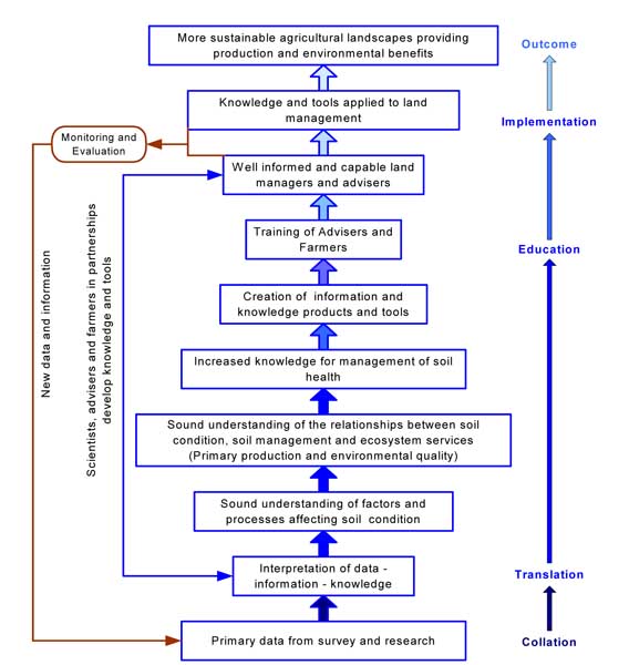
Figure 12 Theory of action developed for Healthy Soils project showing relationship between data, information, knowledge, training, implementation and desired outcomes.
© State of Victoria (Agriculture Victoria) 1996 - 2025.

This work, Victorian Resources Online, is licensed under a Creative Commons Attribution 4.0 licence. You are free to re-use the work under that licence, on the condition that you credit the State of Victoria (Agriculture Victoria) as author, indicate if changes were made and comply with the other licence terms.
The licence does not apply to ‘branding’ or some ‘images or photographs’ that may be owned by third parties. We ask you to seek prior approval to use images using the VRO feedback form. Access to higher quality images can also be provided on request.
This page was last updated on 23/03/2020.