Your gateway to a wide range of natural resources information and associated maps

Victorian Resources Online

Primary Production Landscapes of Victoria - Southern Uplands

Primary Production Landscapes Home

Land use

The Southern Uplands occur east and west of Port Phillip Bay with nature conservation a major land use. Grazing, dairy and forestry represents 98% of the regions agricultural land use while 12% of Victoria’s horticulture and intensive animal production also occurs here. Urban expansion and development continues on the Mornington Peninsula.

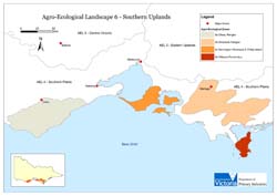
Primary Production Landscapes

Otway Ranges
Slopes with soils of moderate to high inherent fertility are subject to significant rainfall and are prone to mass movement. Cleared parcels of land within forested areas are mainly used for dairy and grazing (beef cattle).

Strzelecki Ranges
Steep slopes of cretaceous sediments are largely cleared and subject to mass movement. Gradational soils of moderate to high inherent fertility are used for dairy, grazing and horticulture.

Mornington Peninsula & Phillip Island
The moist to dry dissected plateaus have strongly weathered terrain with mottled texture contrast soils and occasional sand sheets. Highly productive basaltic soils are used for horticulture including viticulture and vegetable production.

Wilsons Promontory
These granitic mountains and hills are relatively isolated from mainland Victoria with rainfall significantly higher here than the Mornington Peninsula and Phillip Island. Sandy soils are used for nature conservation purposes.

Southern Uplands legend

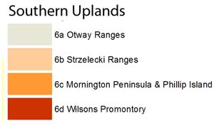
Management practices and issues in response to Climate Change
  • Adoption of intensive dairy farming techniques has increased production from these systems.
  • With increasing production, intensification and drier seasons, further feed inputs are required to maintain milk production.
  • Consolidation of farms and potential competing industries such as horticulture (e.g. potatoes) is continuing. A reduction in the number of new entrants to dairy is a significant change for the industry.
  • Use of weed control chemicals has been a major change to traditional farming practices.
  • Animal health has improved largely due to reduced waterlogging of pastures that causes lameness.
  • Competition for water resources is a major focus at present through drier seasons. Forestry and dairy are competing directly here.
  • Land with water and reliable rainfall is increasingly difficult to acquire as prices have increased markedly through competition with other farming systems and land uses (forestry, horticulture, amenity and lifestyle farming) and investment in dairy by New Zealand dairy farmers.
  • Price of fuel, power and utility supply remain issues in operation of dairies.


Southern Uplands aerial photo

Future scenarios for farming systems
  • Dairy farming is expected to remain profitable and attractive to investors.
  • Land with marginal rainfall is struggling. This occurs for both dairy and forestry where production capacity is less than desired.
  • In response to climate change, tree species that require less rainfall and will cope with stresses such as frosts will be sought in farm forestry.
  • Impacts of carbon emissions trading on forestry and dairy are unknown.
Southern Uplands - landuse Thorpdale
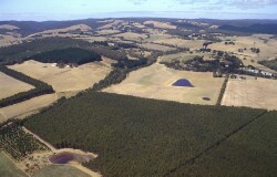
Landuse near Thorpdale

Victoria’s changing climate

Southern Uplands Forrest
Southern Uplands Korrumburra
Southern Uplands Phillip Island
Southern Uplands Graphs legend

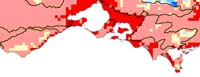
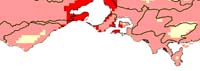
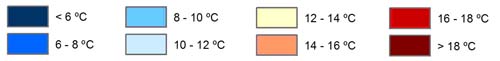
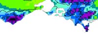
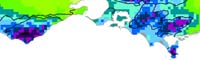
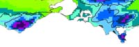
Mean annual temperature (two scenarios from past records and one predicted scenario)

1970-1995
1996-2005
2050 A1FI prediction
Southern Uplands temp 1970-1995
Southern Uplands temp 1996-2005
Southern Uplands temp 2050
Southern Uplands temp legend

1970-1995
1996-2005
2050 A1FI prediction
Southern Uplands Rainfall 1970-1995
Southern Uplands Rainfall 1996-2005
Southern Uplands Rainfall 2050
Southern Uplands Rainfall legend
Page top