
Soil salinity
|
What is it? | 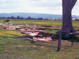 Bare ground produced by salt accumulation with erosion occurring as a consequence |
Impact
Salinity reduces plant production and can damage communities as farm income drops and spending within a community decreases. The physical environment changes both in the immediate area (with degradation of wildlife habitat and the environment) and down-stream from the affected areas. Rivers and streams receive salt laden run-off and sediment as soil structure degrades and erosion occurs. The quality of water supplies for urban, livestock and domestic purposes deteriorates.
Secondary salinity occurs throughout Victoria, with 120,000 hectares identified to date.
Salt affected soil profiles can cause considerable disruption to agricultural ecosystems. A Soil and landscape assessment in the upper Bet Bet Creek catchment is provided to demonstrated this.
Management
Rarely can one land manager solve a salinity problem. While sometimes causes and effects can be seen within a single farm; mostly the cause and effects cross property boundaries. Everyone in a catchment is affected by the agricultural activities of others in it. Therefore effective salinity management requires a total catchment approach.
Since the establishment of Victoria's salinity management program in 1998, the State Government, supported by the Commonwealth, has worked in partnership with communities to develop and implement Salinity Management Plans.
Related Links
Much salinity planning has been carried out in Victoria since 1998. This is summarised on the salinity program page. Mapping information is available also - see Mapping Soil Salinity using Satellite Imagery.
© State of Victoria (Agriculture Victoria) 1996 - 2025.

This work, Victorian Resources Online, is licensed under a Creative Commons Attribution 4.0 licence. You are free to re-use the work under that licence, on the condition that you credit the State of Victoria (Agriculture Victoria) as author, indicate if changes were made and comply with the other licence terms.
The licence does not apply to ‘branding’ or some ‘images or photographs’ that may be owned by third parties. We ask you to seek prior approval to use images using the VRO feedback form. Access to higher quality images can also be provided on request.
This page was last updated on 23/03/2020.