
5.1.4 Hummocky dunes dominant (south east of Lake Tyrrell, north and south of Lake Hindmarsh)
5. North Western Dunefields and Plains (DP)
5.1 Calcareous Dunefields
| Sub-round dunes occur on plains to the south and east of Lake Tyrrell. There are also smaller areas in the valley to the north and south of Lake Hindmarsh. Weakly developed north east - south west ridges also occur, mostly to the east of Lake Tyrrell. Geological maps show that, in these areas, the Woorinen Formation is underlain not by Blanchetown Clay, but by weathered Parilla Sand. This more porous substrate may have favoured the development of sub-round rather than linear dunes. Stranded ridges are absent or weakly developed. Boundaries are clear except to the east of the area near Lake Tyrrell where, unit 5.1.5 has similar landforms but in different proportions. Alluvial plains of the Tyrrell and Lalbert Creeks cross the area from south to north. | 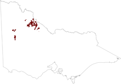 |
The subdued dunes are generally 200 to 500 m across. As in the linear dunes of the Woorinen Formation, the surface soil is underlain by Palaeosols which approximately parallel the land surface. However the clay content of the layers is higher. Medium-textured Calcarosols predominate and gilgaied clays occupy the gentler lower western slopes and intervening plains.
We have detected that the browser used to view this content is missing the supported 'Flash Player plugin'. You need to install the Adobe Flash Player to see this video.
Once you have installed the 'Flash Player plugin' found on the Adobe website, please return to this web page by using the back button on your browser.
This video clip runs for 1 minute and 35 seconds and is 3.8MB in size, this will take some time to automatically download if you are using a slow internet connection. Click the 'play' button and the video should display directly in your browser if this does not happen you need to update the 'Adobe Flash Player'. This software can be downloaded for free from the Adobe website (external link). A transcript of this video is available.
Very little of the native vegetation remains, but it is mostly mallee scrub which tends to be taller and more open on the gilgaied plains.
| The unit is relatively productive under agriculture, having a high proportion of medium-textured soils with favourable structure, water retention and fertility. The erosion hazard is moderate, the most susceptible sites being the upper western slopes most exposed to the prevailing strong winds. Seepage salting has not been observed. Two factors limiting this hazard are apparent, firstly the relatively high water-holding capacity of the upper layers on the hummocky dunes, and secondly the relatively porous substrate, namely Parilla Sand. | 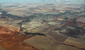 5.1.4 an example of hummocky dunes dominant (south east of Lake Tyrrell, north and south of Lake Hindmarsh |
© State of Victoria (Agriculture Victoria) 1996 - .

This work, Victorian Resources Online, is licensed under a Creative Commons Attribution 4.0 licence. You are free to re-use the work under that licence, on the condition that you credit the State of Victoria (Agriculture Victoria) as author, indicate if changes were made and comply with the other licence terms.
The licence does not apply to ‘branding’ or some ‘images or photographs’ that may be owned by third parties. We ask you to seek prior approval to use images using the VRO feedback form. Access to higher quality images can also be provided on request.
This page was last updated on .