
3.2.2 Ranges (Barrabool Hills, Athlone)
3. Southern Uplands (SU)
3.2 Low relief (low elevation, about 100 - 250 m)
| West of Port Phillip Bay The Barrabool Hills comprises a tilt-block of Cretaceous Otway Group sandstones and mudstones rising from approximately 20 m elevation to a maximum of 211 m along the northern edge (at Bayview). They are bounded to the north by the Barrabool Fault and dissected by tributaries of the Barwon River on the north and east of the block. Landforms are characteristically rounded hills separated by broad valleys. Drainage is weakly rectilinear, favouring south-east and north-east directions for the tributaries of the Barwon River (which bounds the northern edge) and the Waurn Ponds Creek (which drains the southern portion of the block). The Cretaceous hills south of Colac are an outlier of the Otway Ranges, forming a north-east to south-west trending ridge with a maximum elevation of 320 m. In places the dissection is pronounced (e.g. Escarpment Road) making the landform transitional to deeply dissected uplands (geomorphological unit 3.1.2). | 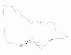 |
Soil types include sands and sands with pans ("coffee rock"), Tenosols and Podosols, gradational soils (Dermosols) in the wetter areas and mottled texture contrast soils (Chromosols) on the drier Barrabool Hills. Depending on the rainfall, the original vegetation probably comprised Lowland Forests, Grassy Forests or Grassy Woodlands.
East of Port Phillip Bay
Dissected ranges have not been described East of Port Phillip Bay.
© State of Victoria (Agriculture Victoria) 1996 - .

This work, Victorian Resources Online, is licensed under a Creative Commons Attribution 4.0 licence. You are free to re-use the work under that licence, on the condition that you credit the State of Victoria (Agriculture Victoria) as author, indicate if changes were made and comply with the other licence terms.
The licence does not apply to ‘branding’ or some ‘images or photographs’ that may be owned by third parties. We ask you to seek prior approval to use images using the VRO feedback form. Access to higher quality images can also be provided on request.
This page was last updated on .