
3.2 Low relief (low elevation, about 100 - 250 m)
- 3.2.1 Plateau and broad ridges (Arthur's Seat, Grantville-Drouin, Cape Woolamai)
- 3.2.2 Ranges (Barrabool Hills, Athlone)
- 3.2.3 Basaltic residuals (Warragul, Red Hill)
3. Southern Uplands (SU)
3.2.1 Plateau and broad ridges (Arthur's Seat, Grantville-Drouin, Cape Woolamai)
3.2.2 Ranges (Barrabool Hills, Athlone)
3.2.3 Basaltic residuals (Phillip Island)
| West of Port Phillip Bay Uplands of low elevation are represented in the Corangamite Catchment Management Authority region by the Barrabool Hills and the hills south of Colac (Yahoo Creek, Wonga Park). These are comprised of Cretaceous Otway Group rocks. East of Port Phillip Bay Southern uplands of low elevation east of Port Phillip Bay are located two areas; the central part of the Mornington Peninsula and along the western flank of the Strzelecki Ranges from Grantville to north of Warragul. South and east of Arthur’s Seat on the Mornington Peninsula is a dissected plateau of low relief, much of which is comprised of Paleogene basalt and described further in section 3.2.3. This plateau is the southern part of the Mornington Horst, a fault bounded broad plateau of moderate elevation formed as a result of two north-east trending faults, the Selwyn and Tyabb Faults. The highest point is Arthur’s Seat, which is a prominent granite hill about 270 m above sea level. From here the plateau slopes away to the south-east. Most slopes are gentle, resulting in a landform pattern best described as undulating to rolling low hills. The drainage pattern is centrifugal, with weak north-easterly flowing streams. | 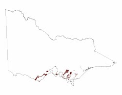 |
The dissected plateau to the west of the Strzelecki Ranges extending from Grantville to north of Warragul is also bounded by faults. The western side of the plateau is defined by the Heath Hill Fault and to the east by the Darnum Monocline and the down-thrown side of the Bass Fault, all of which trend towards the north-east. The land surface generally slopes to the north-west, and in the southern part of the plateau, results in an unidirectional drainage pattern. Most of the northern half of the plateau is comprised of Palaeogene basalt (see section 3.2.3) with some Palaeozoic sediments in the north-western part. The southern part is mostly comprised of lower Cretaceous sediments that may be mantled with sand on the western flank. It is believed that during the Palaeogene a plain developed which was later uplifted by faulting and followed by dissection. What appears to be a paleosurface remnant occurs around Ripplebrook.
The Lang Lang and Bass Rivers and their tributaries have incised into the plateau, cutting valleys up to 50 m below the surface. Other incised streams include Musk Creek and King Parrot Creek. These steams all have well defined flood plains but only along the Bass River are discontinuous terrace remnants to be found.
Related information on VRO
© State of Victoria (Agriculture Victoria) 1996 - .

This work, Victorian Resources Online, is licensed under a Creative Commons Attribution 4.0 licence. You are free to re-use the work under that licence, on the condition that you credit the State of Victoria (Agriculture Victoria) as author, indicate if changes were made and comply with the other licence terms.
The licence does not apply to ‘branding’ or some ‘images or photographs’ that may be owned by third parties. We ask you to seek prior approval to use images using the VRO feedback form. Access to higher quality images can also be provided on request.
This page was last updated on .