
Project Location
Eco-Rich Grazing | Project Team | Publications | Photos | Project Location | Research | Related Links
| Grazing Management Experiments-Volcanic Plains Three sites across the Western Basalt Plains were chosen to conduct the experimental grazing management research, these were Birregurra (near Colac), Darlington and Hamilton. All three sites are characterised by Western Basalt Plains Grassland, although the sites each differ in the cover of native and exotic perennial and annuals.The Western Victorian Volcanic Plain Bioregion is located in central south-western Victoria and covers approximately 21 000 ha. The area has been subject to unregulated grazing for over 150 years and substantial areas have been cropped or sown to exotic pasture over the past 100 years. As a result the landscape has been substantially modified with little remnant native vegetation remaining and is now estimated to occupy less than 1% of its former extent. | 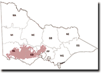 Volcanic Plains of Western Victoria Map courtesy of DSE website. |
Contrary to popular perception, the entire region was not a vast treeless plain, rather an area comprised of a number of geological formations and many distinct vegetation types. Over 70 Ecological Vegetation Classes (EVC’s) and several floristic communities, complexes and mosaics, both treed and treeless have been identified across the Volcanic Plain Bioregion, including once expansive areas of the floristic community Western Plains Grassland dominated by Kangaroo Grass (Themeda triandra). This community was thought to originally occupy 220 073 ha of the Victorian Volcanic Plain but has been significantly depleted and is now estimated to occupy less than 1% of its former extent.
Bluebush Establishment Experiments-Northern Riverine of Victoria
 Grazing on the Northern Riverine Plain | The Bluebush establishment experiment is located on the Northern Riverine Plains of Victoria, just west of Echuca. The region supports a range of farming industries including wheat, sheep, dairy cattle, beef cattle, fodder crops, grapes, canola and oil crops, tomatoes, fruits, carrots and other vegetables and flowers. Large areas are now occupied with vineyards and fruit orchards and olive oil plantations have also been established. As a result of intensive farming practices, much of the native vegetation has been cleared. Much the vegetation present at time of European settlement included grasslands, Maireana shrublands and woodland communities. |
© State of Victoria (Agriculture Victoria) 1996 - 2025.

This work, Victorian Resources Online, is licensed under a Creative Commons Attribution 4.0 licence. You are free to re-use the work under that licence, on the condition that you credit the State of Victoria (Agriculture Victoria) as author, indicate if changes were made and comply with the other licence terms.
The licence does not apply to ‘branding’ or some ‘images or photographs’ that may be owned by third parties. We ask you to seek prior approval to use images using the VRO feedback form. Access to higher quality images can also be provided on request.
This page was last updated on 23/03/2020.