
S7 Kororoit Creek, Altona North - Valley Profile
|
This information has been developed from the publications:
|
| Location | Sunshine - 090093. Former City of Altona. Valley of Kororoit Creek south of Blackshaws Road, Altona North. | 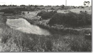 S7 - Kororoit Creek valley, Altona North. |
Access | Blackshaws Road. | |
Ownership | Crown land. | |
Site Description | The site is a meander of Kororoit Creek with a terrace and remnant of a meander cutoff on the western valley. | |
Significance | Local. The site contrasts with the deeply incised sector of Kororoit Creek north of the Princes Highway. | |
Management | Class 3. The site should be maintained as open space and not reclaimed or densely planted with trees. | |

© State of Victoria (Agriculture Victoria) 1996 - 2025.

This work, Victorian Resources Online, is licensed under a Creative Commons Attribution 4.0 licence. You are free to re-use the work under that licence, on the condition that you credit the State of Victoria (Agriculture Victoria) as author, indicate if changes were made and comply with the other licence terms.
The licence does not apply to ‘branding’ or some ‘images or photographs’ that may be owned by third parties. We ask you to seek prior approval to use images using the VRO feedback form. Access to higher quality images can also be provided on request.
This page was last updated on 23/11/2018.