La5 Port Lillias and Bird Rock - Lava Coastline
|
This information has been developed from the publications:
|
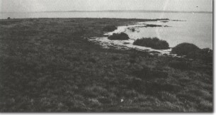
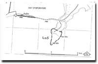
| Location | Lara - 757808. Former Shire Corio. Peninsula 2 km east of Limeburners Bay. |  La5 - Low basalt bluff and emerged shell beds, Point Lillias. |
Access | Avalon Road. | |
Ownership | Private land and Crown land. | |
Site Description | Point Lillias is a narrow peninsula formed by a southward trending ridge of lava of the volcanics of the Werribee Plains. The seaward end of the ridge forms a low bluff fringed by shelly beach ridges. 500 m seaward is a small basalt island (Bird Rock) that indicates the original extent of the lava tongue. In the intervening area, a sandy bar has accumulated on the submerged basalt surface linking Bird Rock to Point Lillias. The bar is completely subaqueous | |
Significance | Regional. Point Lillias is one of the few rocky peninsulas in the study area and illustrates the development of coastal features on a lava surface. Although all the coastline of the study area has developed by the drowning of the edge of the Werribee lava plain, Bird Rock is the only emerged, offshore remnant of the lava flows. | |
| Management | Class 2. Quarrying, road works, jetty, residential or other constructions should not be permitted in the area of the site. The open water link between Bird Rock and Point Lillias should be maintained and dredging of, filling or building coastal structures across this area should not be permitted. |


