
La4 Limeburners Bay - Estuary
|
This information has been developed from the publications:
|
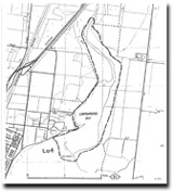
| Location Access Ownership | Lara - 725825. Former Shire of Corio. Estuary of Hovells Creek, 10 km north of Geelong. The Esplanade of Shell Road. Crown land and some private land. | 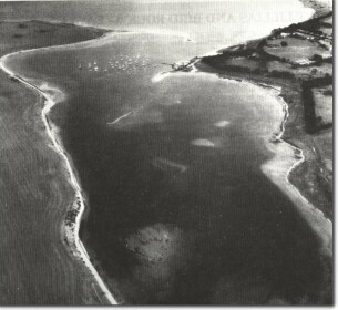 La4 - Limeburners Bay estuary. |
Site Description | Limeburners Bay is a funnel-shaped estuary at the mouth of Hovells Creek. The entrance, at Point Abeona, is partly enclosed by a narrow, recurving shelly spit, the form and position of the distal end of this spit changing frequently in response to variable wave regimes and sand movement from the east. A broader and shorter spit also projects into the inlet from near the boat launching area but this is more stable being subject to a less variable wave regime. | |
| This spit, and the shoal that extends from it, divide the estuary into two basins. The lower basin includes the deepest point in Limeburners Bay (over 6 m in the throat of the flood tide channel opposite Point Abeona), but the basin shallows rapidly to be 2 to 3 m deep opposite the boat launching area. The upper basin averages 1 m in depth, and at low tide a broad area of sand and mud is exposed around the margins. | ||
| The upper parts of this basin, the narrow submerged valley sector of Hovells Creek, and tidal creeks draining from the west, are fringed by a low woodland of mangrove Avicennia marina (White Mangrove). Behind the mangroves is a shrubland dominated by Sclerostegia arbuscula (Shrubby Glasswort) which forms dense thickets up to 1.5 m high and there are many other salt marsh species. There is a broad but scattered zone of Halosarcia halocnemoides subsp. holocnemoides (Grey Glasswort) in the salt pans at the edge of the salt marsh. Twelve species of foraminifera have been recorded from the intertidal flats of the estuary. | ||
There are several types of shoreline around Limeburners Bay. On the western side near the entrance there is a short sector of active marine cliffing, exposing a very clear contact between a basalt flow and the underlying Moorabool Viaduct Sands. Elsewhere the cliffs have degraded to become inactive bluffs fringed by terraces of sand and shells that rise up to 1.5 m above high water mark. In places, the outer edge of these terraces is being cut back by wave erosion. Radiocarbon dating of marine shells from valley-side terraces up to 2 m above present high water mark, indicates the possibility of a higher sea level in the estuary 5,000 to 6,000 years ago. | ||
Significance | State. Limeburners Bay is a classical funnel-shaped compound estuary, with a broad lagoon partly enclosed by a barrier spit and a drowned river valley forming the narrow upper estuarine sector. Many features typical of larger estuarine systems are found in close proximity, such as active cliffs, marginal bluffs, active and relict spits, mangrove and salt marsh zones, and terraces and other deposits suggestive of higher sea levels. The site is an outstanding one to demonstrate many physiographic, hydrological and ecological features of estuaries and coastal lagoons and provides the opportunity for studies in tidal circulation, salinity variation and the dynamics of spit growth. The site is easily accessible from the western side of Melbourne and provides the best example of a compound estuary system close to the Melbourne area. It is a research and educational resource of considerable value. | |
Management | Class 1. A detailed management plan to allow protection of the scientifically significant features of Limeburners Bay is urgently needed. It is recommended that the following actions be taken to protect several of the principal features of the estuary. | |
1. Dredging or deepening of the entrance channel not be permitted. 2. No structures or excavations be permitted on either of the spits. 3. No reclamation, dredging or filling be permitted on any part of the eastern shoreline or on the western shoreline upstream of the Corio Sailing Club installations. 4. The cliffed sections on the western side should remain as active cliffs. No artificial structures, beach nourishment, or engineering works should be undertaken to alter the cliff regime. Artificial drainage should be directed away from the cliff and the present street drain that emerges at the northern end of the cliff should be relocated well to the south. 5. The area adjacent to the salt marsh and mangroves is heavily vandalised by vehicle movement. Adequate fending, signposting and enforcement should be undertaken to prevent this inappropriate use of the area. The rough roadway into the firing range should be relocated and the present track closed. | ||
References | Barson, M.M. and Calder, D.M. (1976). Bell, K.N. (1978). Recent Foraminifera from Limeburners Bay. Vic. Nat. 96: 133-136. Farrell, M.J. (1973). | |
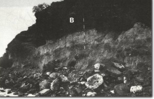
La4 - Basalt (B) overlying Tertiary sediments, Limeburners Bay.

© State of Victoria (Agriculture Victoria) 1996 - 2025.

This work, Victorian Resources Online, is licensed under a Creative Commons Attribution 4.0 licence. You are free to re-use the work under that licence, on the condition that you credit the State of Victoria (Agriculture Victoria) as author, indicate if changes were made and comply with the other licence terms.
The licence does not apply to ‘branding’ or some ‘images or photographs’ that may be owned by third parties. We ask you to seek prior approval to use images using the VRO feedback form. Access to higher quality images can also be provided on request.
This page was last updated on 23/11/2018.