
Bf5 Moorabool River, Batesford - Tertiary Sections
This information has been developed from one or more of these publications:
|
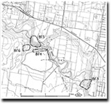
| Location | Batesford - 623793. Former Shire of Bannockburn. East side of Moorabool valley, 2 km south of Batesford. | 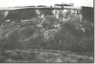 Bf5 - Batesford Limestone (L), Fyansford Formation (F) and Newer Basalt (N), Moorabool River, Batesford. |
Access | From Midland Highway. | |
Ownership | Private land. | |
Site Description | The site is a cliff and former quarry that exposes the upper surface of the Batesford Limestone in contact with the overlying Fyansford Formation. Clay beds of Fyansford Formation interdigitate with limestones marking the transition zone between the two formations. As the composition of the beds also changes laterally from clayey to sandy, it is not possible to select any particular bed as the boundary of the formations. The uppermost part of the cliff also exposes the contact between Moorabool Viaduct sand overlying the Fyansford Formation. The Fyansford beds have a gentle dip to the southeast and the contact with the overlying Moorabool Viaduct beds is a low angle unconformity. The top of the section is capped by Newer Volcanics basalt. | |
Significance | State. This is the best accessible exposure of three of the major Tertiary formations of the Geelong area. It is the only locality where a true unconformity has been observed between the Fyansford Formation and the Moorabool Viaduct Sand. | |
Management | Class 1. The site should not be reclaimed or artificially stabilized or regraded. The outcrops should be retained as an accessible reference site without the need for examination of the quarry. | |
Reference | Bowler, J.M. (1963). Tertiary Stratigraphy and Sedimentation in the Geelong/Maude Area, Victoria. Proc. R. Soc. Vict. 76:69-137. | |

© State of Victoria (Agriculture Victoria) 1996 - 2025.

This work, Victorian Resources Online, is licensed under a Creative Commons Attribution 4.0 licence. You are free to re-use the work under that licence, on the condition that you credit the State of Victoria (Agriculture Victoria) as author, indicate if changes were made and comply with the other licence terms.
The licence does not apply to ‘branding’ or some ‘images or photographs’ that may be owned by third parties. We ask you to seek prior approval to use images using the VRO feedback form. Access to higher quality images can also be provided on request.
This page was last updated on 23/11/2018.