
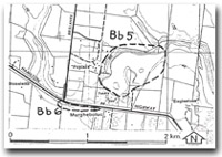
Bb5 Murgheboluc - Barwon River Abandoned Channels
|
This information has been developed from the publications:
|
| Location | Bannockburn - 500790. Former Shire of Bannockburn. North of the Hamilton Highway and at the rear of the recreation reserve at Murgheboluc, 7 km east of Inverleigh. | 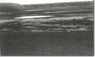 Bb5 - Barwon River abandoned channels |
Access | Hamilton Highway. | |
Ownership | Private land. | |
Site Description | Depressions and wetlands at the base of a high arcuate bluff are abandoned channels of the Barwon River. Upstream, the Barwon is confined in a gorge cut in basalt from Mount Pollock but at Murgheboluc there is no lava on the northern side of the valley and the valley has widened in the less resistant Fyansford Formation and overlying Moorabool Viaduct Sands. The valley widening occurred while the river was blocked and diverted by a Newer Volcanic lava flow; eventually the river re-established an incised course through the younger lava and the northern part of the widened valley was abandoned. | |
Significance | Regional. The site illustrates an unusual place in the development of the Barwon River and shows the importance of rock resistance in determining the form of the valley. | |
Management | Class 2. The wetlands should not be drained or filled and the topography should be retained in its undulating form to display the character of the former river channels. | |

© State of Victoria (Agriculture Victoria) 1996 - 2025.

This work, Victorian Resources Online, is licensed under a Creative Commons Attribution 4.0 licence. You are free to re-use the work under that licence, on the condition that you credit the State of Victoria (Agriculture Victoria) as author, indicate if changes were made and comply with the other licence terms.
The licence does not apply to ‘branding’ or some ‘images or photographs’ that may be owned by third parties. We ask you to seek prior approval to use images using the VRO feedback form. Access to higher quality images can also be provided on request.
This page was last updated on 23/11/2018.