
B1 Somerton Road - Bulla Granodiorite
|
This information has been developed from the publications:
|
| Location | Broadmeadows - 165323; Shire of Bulla. Small valley tributary to Yuroke Creek on northern side of Somerton Road east of Greenvale Reservoir. | 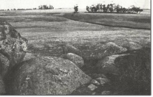 B1 - Bulla Granodiorite. |
Access | Somerton Road. | |
Ownership | Private land. | |
Site Description | The valley slopes of this small creek display outcrops of contrasting geology. On the western valley slope is an exposure of the Bulla Granodiorite similar to that at Gellibrand Hill. Inclusions (xenoliths) in the granite are evident on a number of fresh rock surfaces in a small disused quarry. | |
A number of the minor landforms typical of granites eg - small boulders (tors), domed outcrops, and gently sloping rock pavements occur. Outcrop is concealed on the valley floor by alluvium while higher on the eastern valley slope are basalt lava flows from Mt Yuroke. | ||
Significance | Local. The site displays two common rock types of greatly different ages. Although the contact is concealed by alluvial land and colluvial deposits, there is sufficient outcrop for a useful interpretation exercise to be developed. | |
Management | Class 3. Hard rubbish is being dumped in the disused quarry and should be cleared to improve site quality. Use of the site for a variety of open space purposes eg - parkland, replanting, agistment would retain the significant features. | |
References | Geological Survey of Victoria (1863), Sunbury 1:63,360 geological map. | |

© State of Victoria (Agriculture Victoria) 1996 - 2025.

This work, Victorian Resources Online, is licensed under a Creative Commons Attribution 4.0 licence. You are free to re-use the work under that licence, on the condition that you credit the State of Victoria (Agriculture Victoria) as author, indicate if changes were made and comply with the other licence terms.
The licence does not apply to ‘branding’ or some ‘images or photographs’ that may be owned by third parties. We ask you to seek prior approval to use images using the VRO feedback form. Access to higher quality images can also be provided on request.
This page was last updated on 23/11/2018.