
Mount Hydewell
|
This information has been obtained from the report: Eruption Points of the Newer Volcanic Province of Victoria by Neville Rosengren. This report was published in 1994 and was prepared for the National Trust of Australia (Victoria) and the Geological Society of Australia (Victorian Division). The review of eruption points was based on an earlier unpublished manuscript Catalogue of the post-Miocene volcanoes of Victoria compiled by O P Singleton and E B Joyce (Geology Department, University of Melbourne 1970). |
| 37 38 00S 144 13 30E (external link); 7722-4-2 (Yaloak) 550321. 2 km S of Ballan. Geelong-Ballan Road. | 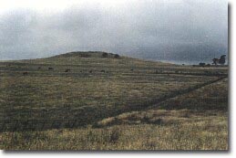 Mount Hydewell | |
Ballan. | ||
Private land: | Grazing, outcrop on steeper summit. | |
Type 2: | Lava shield. | |
Mount Hydewell is a broad lava shield with a small final dome forming the rocky summit. The lavas extend over a broad area. The patterns of lava outcrop suggest there may be a number of closely-spaced eruption points at this site. | ||
537 m: 45 m. | ||
Regional: | This is a representative site to illustrate the development of the broad lava plains south of Ballan. It is an important regional example of a large-volume volcano with low individual eruption points. | |
Class 2: | Roadworks and buildings on the low angle slopes destroy the visual unity of sites of little relief such as this one. | |
References: | Fenner, C. 1918. The physiography of the Werribee River area. Proceedings of the Royal Society of Victoria 31, pp. 176-313. Edwards, A.B. 1938. The Tertiary volcanic rocks of central Victoria. Quarterly Journal of the Geological Society of London 94, pp. 243-320. Ollier, C.D. 1976a. Landforms of the Newer Volcanic Province of Victoria. In J.N. Jennings & J.A. Mabbutt (eds), Landform studies from Australian and New Guinea. ANU Press. pp. 315-339. Roberts, P.S. 1984. Explanatory notes on Bacchus Marsh and Ballan 1:50 000 geological maps. Geological Survey of Victoria Report 76. | |

© State of Victoria (Agriculture Victoria) 1996 - .

This work, Victorian Resources Online, is licensed under a Creative Commons Attribution 4.0 licence. You are free to re-use the work under that licence, on the condition that you credit the State of Victoria (Agriculture Victoria) as author, indicate if changes were made and comply with the other licence terms.
The licence does not apply to ‘branding’ or some ‘images or photographs’ that may be owned by third parties. We ask you to seek prior approval to use images using the VRO feedback form. Access to higher quality images can also be provided on request.
This page was last updated on .