
Soil and Land types of the Lower Maribyrnong Valley (and erosion risk ratings)
This survey in the valley of the Lower Maribyrnong River, carried out for the former MMBW, by Rosemary Hook and David Howe, of the former Soil Conservation Authority (SCA) in 1984; aimed to identify the different land types, principally on the basis of soil and landscape, and to assess their erosion risk following disturbance and track development. The information formed part of the physical data base on which the development and management of the Maribyrnong River Park was planned.
To view the information PDF requires the use of a PDF reader. This can be installed for free from the Adobe website (external link).
 | (PDF 314KB) | 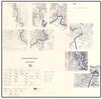 Maribyrnong River Land Units (PDF 245KB) |

© State of Victoria (Agriculture Victoria) 1996 - 2025.

This work, Victorian Resources Online, is licensed under a Creative Commons Attribution 4.0 licence. You are free to re-use the work under that licence, on the condition that you credit the State of Victoria (Agriculture Victoria) as author, indicate if changes were made and comply with the other licence terms.
The licence does not apply to ‘branding’ or some ‘images or photographs’ that may be owned by third parties. We ask you to seek prior approval to use images using the VRO feedback form. Access to higher quality images can also be provided on request.
This page was last updated on 23/11/2018.