
GP22
| Location: Clyde. | Australain Soil Classification: Ferric-Sodic, Eutrophic, Brown CHROMOSOL. |
| Northcote Factual Key: Dy 3.31 | Great Soil Group: soloth/solodic. |
| Geology: Tertiary sandstone (some areas may be covered with a veneer of Quaternary aeolian deposits). The rock may be in the order of 10-20 million years old and consists mainly of iron oxide cemented clays and sands (pers. comm. Jim Rowan). | |
| General Landscape Description: Gently undulating rises. | Site Description: Grassed verge on the edge of a celery cropping paddock. |
| Soil Mapping Unit: Bittern sandy loam. | |
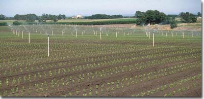 Site GP22 Landscape |
Soil Profile Morphology:
Surface Soil
| A1 | 0-20 cm | Dark brown (10YR3/3); sandy loam; pH 7.0; clear change to: | 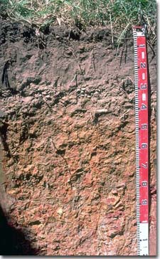 Site GP22 Profile |
| A2 | 20-35 cm | Sporadically bleached; light sandy loam; firm consistence dry; contains many (40%) iron-cemented sandstone and ferruginous nodules (mainly in the 30-35 cm zone); pH 5.8; sharp change to: | |
| Subsoil | |||
| B21 | 35-80 cm | Yellowish brown (10YR5/4) with bright yellowish brown (10YR5/6) and red (2.5YR4/6) mottles; light medium clay; moderate medium blocky, parting to strong fine sub-angular blocky structure; strong consistence dry; pH 6.4; gradual change to: | |
| B22 | 80-120 cm | Light grey (10YR7/1), yellowish brown (10YR5/8) and red (2.5YR4/6) mottles; light medium clay; strong coarse polyhedral structure; strong consistence dry; contains many (30%) iron cemented sandstone; pH 6.2. |
Key Profile Features:
- Strong texture contrast between surface (A) horizons (16 % clay) and subsoil (B21) horizon (72 % clay).
- Presence of 'ironstone' nodules and ferruginous sandstone fragments at the A/B horizon interface. These may be lag deposits formed during more tropical Tertiary climatic conditions.
- Intensively weathered B horizon with kaolinitic clays approximately 2 million years old (pers. comm. Jim Rowan).
Soil Profile Characteristics:
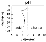 The surface soil is neutral . The rest of the soil profile is slightly acid. | 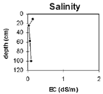 The salinity rating is very low throughout the profile. |
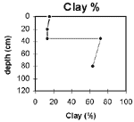 The clay percentage increases sharply at the A/B horizon interface. | 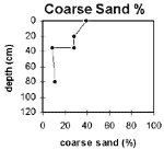 The coarse sand content decreases in the clayey B horizons. |
Horizon | Horizon Depth (cm) | pH (water) | pH (CaCl2) | EC 1:5 | Exchangeable Cations | |||
Ca | Mg | K | Na | |||||
meq/100g | ||||||||
A1 | 0-20 | 7 | 6.5 | 0.14 | 7.7 | 2 | 0.64 | 0.3 |
A2 | 20-30 | 5.8 | 4.7 | <0.05 | 0.97 | 0.85 | 0.06 | 0.07 |
B21 | 35-80 | 6.4 | 5.5 | 0.07 | 2.6 | 7 | 0.1 | 0.4 |
B22 | 80-120 | 6.2 | 5.7 | 0.1 | 1.1 | 7 | 0.11 | 0.98 |
Horizon | Horizon Depth (cm) | Field Capacity pF2.5 | Wilting Point pF4.2 | Coarse Sand (0.2-2.0 mm) | Fine Sand (0.02-0.2 mm) | Silt (0.002-0.02 mm) | Clay (<0.002 mm) |
A1 | 0-20 | 13 | 6 | 39 | 37 | 5 | 16 |
A2 | 20-30 | 13 | 4 | 28 | 47 | 10 | 13 |
B21 | 35-80 | 34 | 25 | 9 | 15 | 6 | 72 |
B22 | 80-120 | 31 | 21 | 11 | 20 | 6 | 64 |
Management Considerations:
Note: This pit site occurs on a grassed verge (never cropped) beside a cropping paddock (see landscape photo). All samples were taken from this pit site except for the surface horizon, which was sampled in the cropped paddock. This was done as the grassed verge site showed evidence of surface disturbance. Surface soil results will therefore more closely represent cropped conditions, but may still not be representative of the whole paddock, as the whole paddock was not sampled.
Whole Profile
- Plant available water capacity (PAWC) is considered to be low (estimated at 85 mm) for the top metre of the soil profile. Rooting depth will vary depending on crop type, so the estimated PAWC should be considered as potential only. PAWC is estimated at approximately 50 mm for the surface horizons (ie. to 35 cm depth).
- The surface (A1) horizon sample was taken from inside the paddock. The neutral pH (ie. pH 7) reflects the use of lime on the surface soil.
- These soils can be prone to waterlogging as the water ponds on top of the relatively slowly permeable clay subsoil. The presence of a sporadically bleached subsurface (A2) horizon indicates that periodic waterlogging occurs. As a result, the A2 horizon is likely to become 'spewy' when wet and restrict traffickability.
- The levels of total nitrogen and organic carbon are relatively low as measured for this one point in the paddock. However, these levels are better assessed by sampling across the paddock.
- Some initial ponding will occur above the very clayey subsoil. However, the upper subsoil is reasonably well structured (parting to relatively fine sized peds) and is non-sodic. Root and water movement through the subsoil is not likely to be as restricted as Site GP21.
- The subsoil has a high level of exchangeable magnesium relative to other cations. This may result in some nutrient imbalances (e.g. potassium deficiency). Nutrient deficiencies can be assessed by plant tissue analysis.

© State of Victoria (Agriculture Victoria) 1996 - 2025.

This work, Victorian Resources Online, is licensed under a Creative Commons Attribution 4.0 licence. You are free to re-use the work under that licence, on the condition that you credit the State of Victoria (Agriculture Victoria) as author, indicate if changes were made and comply with the other licence terms.
The licence does not apply to ‘branding’ or some ‘images or photographs’ that may be owned by third parties. We ask you to seek prior approval to use images using the VRO feedback form. Access to higher quality images can also be provided on request.
This page was last updated on 23/11/2018.