
Geology of the Region
Brief Description of the Geology of the Cranbourne and Koo-Wee-Rup Region
The oldest outcropping rocks in the Cranbourne region are from the Silurian period (approximately 440 - 410 million years ago). During this period, primitive plant life had evolved on land and animal life existed only in oceans. Australia was part of a much larger continent (‘Gondwana’) and did not lie in its present position, but closer to the equator. Throughout the Silurian period, hundreds of metres of sediments (mainly mudstone, siltstone and shale) were laid down within a deep ocean trench which extended from Tasmania into New South Wales. These rocks are now exposed on hilly country near Pakenham, Langwarrin and Pearcedale.
 Road cutting near Langwarrin showing Silurian bedrock. | From the middle Devonian period to the beginning of the Cretaceous period (a span of some 250 million years), most of Victoria was no longer covered by ocean and several thousand metres of sediments were eroded away to form a nearly level plain. This erosion exposed areas of granite which were formed in the middle Devonian period as intruded magmatic material from deep inside the Earth crystallised slowly at depth. Granites are now exposed in the Dandenong’s, Tynong and Baw Baw areas. An outcrop also occurs at Mt. Eliza. |
In the late Jurassic and early Cretaceous periods (160 - 96 million years ago), Australia and Antarctica began to separate. As they moved apart, a large basin (or ‘rift valley’) was formed by subsidence. This basin was then slowly filled by up to 3 000 metres of sediments (sandstones and mudstones) which were deposited by rivers and lakes. Accumulated swamp material would later be compacted to form coal seams in the Wonthaggi area. During this period, the vegetation was dominated by conifers and ferns, and dinosaurs roamed the earth. From the middle Cretaceous period, Australia had moved further away from Antarctica. The stresses caused by this separation resulted in significant folding, faulting and uplifting of the earlier Cretaceous sediments. The uplift resulted in the development of the Otway and Strzelecki Ranges.
During the upper Cretaceous and early Tertiary periods, extensive lava flows occurred along many of the valleys in South Gippsland. Present day outcrops of this basalt material are located in West Gippsland (eg. Warragul, Thorpdale, Mirboo, Leongatha regions) and on the southern Mornington Peninsula around Red Hill. A small outcrop also occurs around Cranbourne and Berwick. In other areas, basalts may have been covered by subsequent Tertiary and Quaternary sediments.
Victoria experienced a warm and wet tropical type climate throughout much of the Tertiary period and temperate rainforest was widespread over much of the state. During the Tertiary period, (from approximately 65 million years ago) Australia continued to drift away from Antarctica (at rates of up to 6 cm per year). Three interconnected marine basins (Otway, Gippsland and Bass) formed along the southern edge of Victoria’s continental plate and significant marine sediments were laid down in shallow seas. Some parts of these basins now lie onshore but most are to be found beneath Bass Strait where commercial oil and gas reserves have been found within these sediments. During the Tertiary period, significant earth movements occurred along fault lines. Subsidence between fault lines resulted in the formation of the Port Phillip and Westernport sunklands. Port Phillip and Westernport Bays were formed within these sunklands as sea levels rose. The sea level fluctuated significantly during Tertiary times.
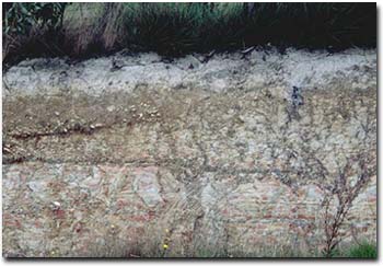
| Following the uplift of the South-Eastern highlands in the late Tertiary period (approximately 5 million years ago), extensive river systems developed over dry land areas. These rivers formed deep channels which were filled with coarse gravels. Some of these have been preserved as river terraces along present day streams. As the uplands became eroded away, the rivers draining them became reduced in size. These slower flowing streams then deposited only finer grained sediments. These Tertiary sediments covered much of the Silurian sediments but have since been largely covered by more recent Quaternary deposits. Outcrops of Tertiary sandstone are widespread in the Cranbourne area. These deposits consist mainly of ferruginous gravel and weakly cemented sandy clays and are referred to on geological maps as Baxter Sandstone. The most recent geological period is the Quaternary, which extends from 1.6 million years ago to more recent geological times. During the Quaternary there were several ice ages which resulted in significant sea-level changes. The most recent ice age peaked approximately 20 000 years ago and sea levels were estimated to be some 120 metres lower than present levels. At these times dry land existed between Victoria and Tasmania. During such arid periods extensive sand deposits were blown by winds and deposited in the Langwarrin and Cranbourne areas. These sands were probably derived from erosion of older Tertiary sands and subsequent relocation by wind to form dunes and sandsheets. | 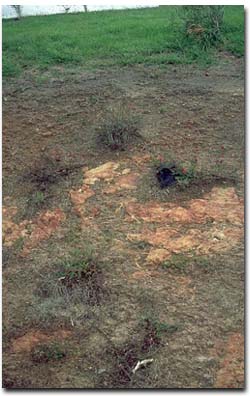 Road cutting near Clyde showing Tertiary sandstone sediments |
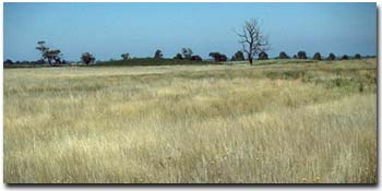
Some of the sand may also have been blown out from what is now Port Phillip Bay. These sand deposits can be as much as 15 metres thick and some of the larger deposits are mined. Figure 5 shows a photograph of sand dunes near Cranbourne. | |
 Sand sheets and sand dunes near Cranbourne | The Cardinia, Dalmore and Koo-Wee-Rup area is part of a former river delta system with sand ridges traversing low-lying swampy terrain. Extensive swamp deposits were laid down in the Westernport sunkland during the late Quaternary to recent period. These sediments were deposited by the Cardinia, Ararat, Toomuc and Deep Creeks. This swamp was known as the Koo-Wee-Rup Swamp and roughly covered the area mapped in this report as Dalmore clay and Koo-Wee-Rup peaty clay. |
The sand ridges in this area are believed to represent levee and channel deposits associated with prior streams (larger than those existing today) (Jenkin 1962). Some sandy crescent shaped dunes also occur in the Cardinia area. These are called ‘lunettes’, and are sandy deposits that were blown out of ancient lake beds during drier climatic times. | |
 Sandy rise (lunette) on eastern side of former lake. | Complex pattern of sand ridges near Koo-Wee-Rup. These represent remnants of older streams. This part of the Narre clay loam with sandy ridges mapping unit. |
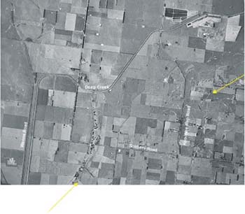
Air photo showing Quaternary period features (a network of sandy ridges and a lunette) in the Koo-Wee-Rup region. | Source: Aerial Photo Westenport 7921 Run 4 (3703-184) Victoria Department of Crown Lands and Survey (Nov. 1972) |
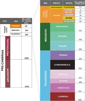
Geological time chart (adapted from Cochrane et al (1991).
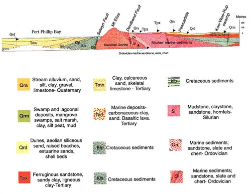
Geological Cross Section of the Port Phillip - Westernport region. Source: Queenscliff 1:250 000 Geological map - Geological Survey of Victoria, 1971.
References
Cochrane, G.W., Quick, G.W. and Spencer-Jones, D. (eds.) (1991). Introducing Victorian Geology. Geological Society of Australia (Victorian Division), Melb.
Douglas, J.G and Ferguson, J.A (eds.) (1988) Geology of Victoria. Geological Society of Australia (Victorian Division), Melb.
Jenkin, J.J (1962). The geology and hydrogeology of the Western Port area. Undergr. Wat. Invest. Rept. Geological Survey, Victoria 3.

© State of Victoria (Agriculture Victoria) 1996 - .

This work, Victorian Resources Online, is licensed under a Creative Commons Attribution 4.0 licence. You are free to re-use the work under that licence, on the condition that you credit the State of Victoria (Agriculture Victoria) as author, indicate if changes were made and comply with the other licence terms.
The licence does not apply to ‘branding’ or some ‘images or photographs’ that may be owned by third parties. We ask you to seek prior approval to use images using the VRO feedback form. Access to higher quality images can also be provided on request.
This page was last updated on .