
General Land Use
A Brief Description of the Land Use in the Koo-Wee-Rup and Cranbourne Regions
The Koo-Wee-Rup region
The following history of the Koo-Wee-Rup region in terms of drainage and agricultural production has been largely summarised from the Book 'From Swampland To Farmland' by David Roberts. It is essential reading for anyone interested in the history of this region.
Early drainage of the Koo-Wee-Rup swamp
In the 1800's the Koo-Wee-Rup swamp extended over an area of approximately 40 000 hectares. It was covered by dense stands of swamp paperbark (Melaleuca ericifolia), reeds (Phragmites australis) and bullrushes (Typha spp) and provided a natural barrier between Melbourne and West Gippsland.
The Land Act of 1865 opened up land along the fringes of the swamp for selection. However, farming was not possible due to potential flooding and dense stands of vegetation. By 1870 the Lands Department decided that the swamp should be drained and opened up for agriculture. Further land was sold at auction in 1875. The largest landholders at the time were Scottish and may have believed that the swamp soils were favourable for farming, based on their knowledge of peaty soils in their mother country. Landholders formed the Koo-Wee-Rup Swamp Drainage Committee which would be responsible for draining the area.
In February 1876 works commenced on excavation of a main channel (8 km long and 1.2 m deep) which tapped the Cardinia Creek and channelled water into Westernport Bay at Moody's Inlet. Other smaller drains (eg. Toomuc) were dug. One of the landholders (McGregor) also built an embankment to hold back water on his property called 'Dalmore'. Landholders carried out drainage works with shovels and wheelbarrows. Vegetation was knocked down and burnt and the land was ploughed. Some farmers flooded each other's land with their own drainage works and major floods still occurred (eg. 1891).
In March 1878 the Gippsland railway which ran from Melbourne to East Gippsland was completed. Residents of Cranbourne and Port Albert made demands for a rail service in their districts which would necessitate a railway going through the Koo-Wee-Rup swampland. Plans were developed for a Great Southern Railway between Dandenong and Port Albert with profits from the sale of drained land to be used for it's construction.
Major drainage schemes
Work commenced on the Bunyip Main Drain in 1889 in order to channel water from the Bunyip river as it entered the swamp. This main drain would be fed by smaller drains. By 1892 the main drain had been cut 14 km inland from Reeces Inlet and at this time some 500 men were working on the project and excavating drains using picks, shovels and wheelbarrows. By 1893 the Main Drain had met the Bunyip Drain. These two drains together with four smaller drains formed the foundation of the swamp drainage system. A village settlement was started on the partly reclaimed swamp, whereby settlers were responsible for the maintenance of drains adjoining their blocks. The main drain overflowed in 1893 and much of the land was flooded. In response, the main drain was widened and deepened.
Two creameries were established in 1896 and by 1897 drainage works were completed. In 1898 bushfires spread to the swamp area and underlying peat soil caught fire and burnt beneath the surface for months. The results of drainage and several dry years resulted in the soil shrinking and compacting and the level of the land surface fell.
A major flood in 1900 resulted in damage to crops (eg. potatoes, onions, oats) and dairy cows drowned. Further widening of the main drain took place and more subsidiary drains were dug. A change from block allocation to land selection resulted in farmers from other regions (eg. Ballarat, Drouin) moving in to the area and bringing cropping skills. In the first decade of the 1900's this area became the 'potato capital' of Victoria.
In the early 1900's, hills to the north of the swamp area were cleared of trees in order to develop farms and to supply the many saw mills established due to a growing timber demand. Increased runoff resulted into the Tarago and Bunyip catchments. Erosion occurred in the steeper sections of the Bunyip main drain and sediments were deposited in the lower sections of the drain. In 1911 severe flooding occurred. A drainage improvement plan was proposed by the State Rivers and Water Supply Commission to give the area complete protection from a flood this size. The Lower Koo-Wee-Rup Flood Protection District was proclaimed in 1917 and work commenced.
Increased demands for vegetables for canning was generated during World War 1 (1914-1918) and vegetable growing was encouraged. Labour shortages at this time were offset by the introduction of a steam-driven bucket dredge, which was used on the wider sections of the larger drains (eg. Main, Yallock, Cardinia). It had a capacity of 60 cubic metres per day (versus 8.5 for a 'good man').
At the end of World War 1, the Government purchased large properties in a number of regions of Victoria and divided them into smaller holdings, which were allocated to returned soldiers. Within this area some of the larger properties (such as 'Dalmore') were subdivided under this scheme. Some minor flooding occurred in 1920 and 1921. By 1923 almost 6500 hectares of potatoes were planted (Goudie 1942).
A thriving sand industry also developed in the area. Sand was excavated from the main drains and transported to Melbourne by railway where it was in demand as building material. The rate of erosion upstream decreased (naturally and as a result of control measures) and the supply of sand was depleted within a few years.
A major flood (double the size of 1911) occurred in 1923, which resulted in significant crop damage. An even larger flood occurred in 1924 that covered the former swampland in water 1.5 metres deep. In 1925 a Royal Commission investigated the entire Soldier Settlement Scheme and assistance was given. Drier periods existed after 1924 and the land proved to be very fertile. Italian migrants bought many of the properties abandoned after the floods. They practised labour intensive farming methods and district production rose. It was estimated by the Department of Agriculture that in 1926 the former swamp area produced approximately 25% of Victorian potatoes. However, the Great Depression in the late 1920s resulted in reduced prices and financial ruin for some farmers. Drainage digging was provided by the Government as a form of relief work for the unemployed.
Extensive flooding occurred in many areas of Victoria in 1934, and resulted in a flood in the former swamp area which was three and a half times larger than the record flood of 1924. Over one thousand people were made homeless and the Koo-Wee-Rup hotel had almost 2 metres of water in it. A Royal Commission was established in 1936 and resulted in a drainage improvement scheme being implemented. This scheme involved alterations (eg. levee construction, sediment removal) and extensions to main drains. Other floods occurred in 1937.
By 1940 the area planted to potatoes had fallen to approximately 570 hectares, due mainly to low prices in the 1930's. Smaller areas were planted to maize, onions, carrots, peas and asparagus (Goudie 1942). Vegetable demand increased during the Second World War and carrots, peas and cabbages were processed in the Dalmore area. The Koo-Wee-Rup district became the prime supplier of vegetables and milk to Melbourne. Only minor flooding occurred after this period as drainage works continued. The whole reclaimed swampland came under the control of one authority (State Rivers and Water Supply Commission) in 1962. | 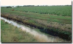 A major drain near Dalmore. |
| The Tarago Reservoir was constructed in 1969 (to supply water to the Mornington Peninsula) which enabled more flood control downstream. | |
Irrigation Due to urban expansion in the 1950's and 60's, market gardeners were forced away from the city region. The Koo-Wee-Rup region became an area of market garden expansion and potatoes replaced dairying as the dominant land use. A system of irrigation was developed to provide for this expansion. In the 1950's, permits were issued to allow a number of landholders to pump water directly from the main drain. Further permits were granted. The amount of water that could be pumped varied according to the size of the farm. Groundwater comes from the Western Port Groundwater Basin which is fed by water entering via Tertiary period gravels and basalts along the eastern and western margins. Also, recharge occurs via Quaternary sediments in the north-east (eg. Bunyip and Tarago river basins). | 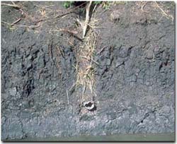 Example of subsurface drainage in Dalmore clay soil. These drains are generally located just below the peat layer and are partially backfilled with gravel |
| Water becomes stored in a groundwater aquifer underneath the impermeable clay and peat layers. The first bore was sunk in 1922 near Cora Lyn to tap underground water. Other bores were sunk and used for stock and domestic requirements. Bore sinking went unchecked in the 50's and 60's and a decline in water levels of up to 15 metres was recorded in 1961-62. During the 1967-68 drought the water level in the Koo-Wee-Rup aquifer fell to below pumping levels. The Groundwater Act was passed in 1969 and control of groundwater extraction was given to the State Rivers and Water Supply Commission. Parts of the Westernport Groundwater Basin were declared a Groundwater Conservation Area in 1971. Controls were placed on the maximum rate and volume of groundwater that could be extracted. Zones were established to manage groundwater use and in some areas no further bores were permitted. | |
The Cranbourne region
Annett and Imhof (1991) assessed changes in landuse for the former shire of Cranbourne from 1979 to 1989. These changes were estimated from aerial photo interpretation. Urban land use increased by an estimated 2200 hectares and in 1989 covered some 8 % of the study area. Much of this urban expansion has occurred around Cranbourne, Hampton Park, Langwarrin and Carrum Downs. Associated with this urban increase has been an increase in sand quarrying. The area excavated for sand had increased an estimated 390 hectares (83%) over the same period. Sand mining in the Cranbourne region supplies about 15 % of Melbourne's sand requirements (Cochrane et al 1991). A large area of Quaternary sand deposits are preserved in the Cranbourne Royal Botanic Gardens extension.
Market gardening on sandy soils had also increased significantly (approximately 40%) over this period. This expansion has occurred primarily as consolidation of existing farms around Cranbourne, Fiveways and Devon Meadows. Smaller, new operations have developed around Pearcedale and Langwarrin. The increase in market gardening has no doubt been a result of migration of these activities from other areas closer to Melbourne (eg. Dingley, Oakleigh) as a result of urban expansion pressures. Continued urban expansion around Cranbourne, Pearcedale and Langwarrin may impact greatly on these operations. In the south-eastern growth corridor it is expected that the metropolitan area will expand to Cranbourne in the south. Cranbourne is anticipated to house about 80 000 people (Melbourne Herald 24/11/90). Apart from using land suitable for market gardening (eg. Cranbourne sands), urbanisation will invariably result in an increase in land prices in surrounding areas. Other problems faced by farmers on the urban fringes include the need for greater security and community concern over some farming practices (eg. spraying near urban areas).
References
Annett, S and Imhof, M.P. (1991) Assessing Changes in Rural Land Use in Gippsland - A Case Study using Geographic Information Systems (GIS). Draft Report, Department of Agriculture.
Cochrane, G.W., Quick, G.W. and Spencer-Jones, D. (eds.) (1991). Introducing Victorian Geology. Geological Society of Australia (Victorian Division). Melbourne.
Goudie, A.G. (1942). A Survey of the Soils and Land Utilisation in the Parishes of Koo-Wee-Rup and Koo-Wee-Rup East. Proc. Roy. Soc. Victoria, 54 (NS) Pt.1:93-130.
Roberts, D. (1985). From Swampland To Farmland - A History of the Koo-Wee-Rup Flood Protection District. Rural Water Commission of Victoria.

© State of Victoria (Agriculture Victoria) 1996 - 2025.

This work, Victorian Resources Online, is licensed under a Creative Commons Attribution 4.0 licence. You are free to re-use the work under that licence, on the condition that you credit the State of Victoria (Agriculture Victoria) as author, indicate if changes were made and comply with the other licence terms.
The licence does not apply to ‘branding’ or some ‘images or photographs’ that may be owned by third parties. We ask you to seek prior approval to use images using the VRO feedback form. Access to higher quality images can also be provided on request.
This page was last updated on 23/11/2018.