
Ya1 - Yaloak Creek - Landslide Slopes
|
This information has been developed from this publication:
|
| Location: | Yaloak - 556258 to Ingliston - 590230. Shire of Ballan. Valley of Yaloak Creek from opposite Fiskville to ‘Yaloak Vale’. | 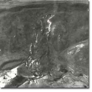 Yaloak Creek - Landslide Slopes |
Access: | Glenmore Road. | |
Ownership: | Private land. | |
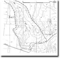
Site Description: | A wide variety of landslide movements occur on the steep slopes of the Yaloak Creek and have caused major deformation of the displaced materials. The slides being at several levels on the slope, some heading at the basalt escarpment and others being generated at some point on the lower slopes. Those heading at the escarpment involve the detachment or topping of long sectors of jointed basalt blocks and result in extensive scree lines. The slides have broad headwells and coalescence of several slides form a continuous mass movement zone several hundred metres wide. The slides are compound features involving a number of types of mass movement, although most have lobate fronts indicating that earthflow is a mechanism in the lower slope movement. | |
Several long landslides extend to the valley floor of the Yaloak Creek, feeding rock debris directly into the stream channel, forming temporary dams and causing channels forms to vary markedly over short distances. A common sequence in recently slumped zones is for a chaotic section, where large boulders are strewn across the channel in front of steeply undercut banks of sand and clay, to be succeeded downstream by wide braided reaches where sand and gravel have been washed from the slump margin. These bed sections are highly permeable. During low flow periods the streams sink and emerge intermittently along these gravely braided reaches. The Yaloak Creek therefore carries a high load of coarse sediment and has deposit this as a broad alluvial floodplain alongside the Glenmore Road. Narrow terraces flank the deeply incised channel of this creek near ‘Yaloak Vale’. | ||
Significance: | State. The site includes the most extensive complex landslip sequence in Victoria. It is a major research site in geomorphology to study the chronology of landslides and determine the factors involved in mass movement. | |
Management: | Class 1. The site poses considerable hazard to any forms of land use other than grazing or limited extractive industry. These do not pose a management issue at the site in terms of the significant features. | |
 Site - Ya1 |

© State of Victoria (Agriculture Victoria) 1996 - .

This work, Victorian Resources Online, is licensed under a Creative Commons Attribution 4.0 licence. You are free to re-use the work under that licence, on the condition that you credit the State of Victoria (Agriculture Victoria) as author, indicate if changes were made and comply with the other licence terms.
The licence does not apply to ‘branding’ or some ‘images or photographs’ that may be owned by third parties. We ask you to seek prior approval to use images using the VRO feedback form. Access to higher quality images can also be provided on request.
This page was last updated on .