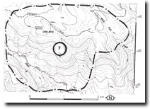
7. Spion Kopje - Granite Outcrop
|
This information has been developed from one or more of these publications:
|
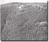
| Location: | Spion Kopje – 983026. Ten kilometres west of Nayook. |  Granite slopes and steep stream channels at Spion Kopje. |
Access: | Limberlost Road via Pioneer Creek Road. | |
Ownership: | Crown Land. | |
Geology/Geomorphology: | This site includes sufficient area to display the typical terrain of the Tynong Granite, the dominant lithology of the northern part of the Westernport Bay catchment. The peak of Spion Kopje (898 metres), is the highest point in the catchment. The site includes Spion Kopje Creek and Black Butt Creek and their tributaries as these streams show parallel alignments that strongly reflect control by the major joint systems in the granite. There are a number of granite outcrops and steep stream channels sectors. | |
Significance: | Regional. The site is a major example of the terrain and geology of the northern part of the Westernport Bay catchment. | |
Management: | Class 2. Timber extraction and quarrying activities should be excluded from the area of the site. | |


