56. Red Bluff - Type Section
|
This information has been developed from one or more of these publications:
|
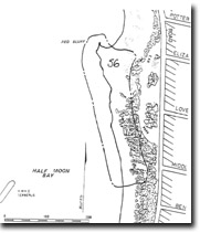
| Location: | 251961. Opposite Eliza St, Black Rock and 600 m north of the Black Rock Yacht Club. |  Site 56, Red Bluff, type locality for the Brighton Group |
Access: | Parking area off Beach Road between Eliza St, and Middleton St, Black Rock. To access the cliff base or to examine the formation, it is necessary to walk down the path to Half Moon Bay. | |
Ownership: | Crown land, City of Sandringham. | |
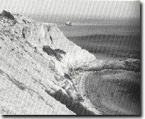
Geology/Geomorphology: | Red Bluff is a high (over 25 m), active cliff cut in poorly consolidated clayey sands, with harder sandstone beds forming a series of irregular ledges and benches at the base. The greater part of the cliff is an exposure of the Red Bluff Sand, this site being the type locality for that geological formation. At the cliff base, the Red Bluff Sand rests disconformably on the hard, dark brown to red ferruginous sediments of the Black Rock Sandstone, about 3 m of Black Rock Sandstone being exposed here above low water mark. These two formations comprise the Brighton Group, the most widespread outcropping Tertiary sedimentary sequence in the Melbourne area. The lowest bed of the Red Bluff Sand is a dark carbonaceous band overlain by a thin, hard, gritty iron cemented bed. Above this, the lower beds of the Red Bluff Sand are yellow clayey sands passing into cross-bedded gravelly horizons which become sandy and brown to red in the upper sections of the cliff. Although not abundant, the fossil pollen and leaf content of clays lens in the Red Bluff Sand indicates the formation is of non-marine origin and of Middle to Late Pliocene age. | |
The headland at Red Bluff coincides with a rise in the level of the Black Rock Sandstone, (either a minor anticline or a depositional undulation in the formation). This rise brings the more resistant ferruginous rock up to sea level and forms the promontory underpinning the cliff. To the south, the cliff declines to be a scrubby bluff behind Half Moon Bay where the Black Rock Sandstone declines below sea level. The face of Red Bluff is incised by narrow, tubular gullies, with remnant pinnacles and buttresses forming a miniature but spectacular ‘badlands terrain’. | ||
Significance: | State. Red Bluff is a type locality for the major surface Tertiary rocks of the central an southeastern areas of Melbourne. It is therefore an important reference site for geological correlation. There is a clear exposure of the contact between the two formations of the Brighton Group, and the site is important also for displaying the structure and texture of non-marine sedimentary deposits. | |
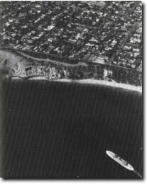
The cliff is one of the few surviving examples of the formerly extensive active coastal cliffs of the northeast of Port Phillip Bay – most having been artificially stabilized or isolated from marine and subaerial erosion. Because there is an extensive graphic record of Red Bluff, it is an important site to demonstrate the earlier configuration of the Port Phillip Bay coast and to allow evaluation of coastline changes and cliff development. | ||
Management: | Class 1. No defensive structures other than beach nourishment should be emplaced around the base of Red Bluff. Drainage works at the cliff top should be designed to minimize and disperse runoff but to allow retention of the ‘badlands’ terrain. No stabilization or revegetation of the cliff face or crest is needed or warranted. Any landscaping or pedestrian access/control works should only be carried out with the intention of retaining the geological/geomorphological values of the site. | |
References: | Hart, T.S. (1893). Notes on rocks of Brighton and Moorabbin and surround districts. Vic. Nat., 9, 156-159. Hall, T.S. & Pritchard, G.B. (1897). A contribution to our knowledge of the Tertiaries in the neighbourhood of Melbourne. Proc. R. Soc. Vict., 8, 1-23 Hall, T.S. & Pritchard, G.B. (1897). Notes on a tooth of Palorchestes from Beaumaris. Proc. R. Soc. Vict., 10, 57-59. Gill, E.D. (1950). Nomenclature of certain Tertiary sediments near Melbourne, Victoria. Proc. R. Soc. Vict., 62, 165-171. Gill, E.D. (1957). The stratigraphical occurrence and palaeoecology of some Australian Tertiary marsupials. Mem. Nat. Mus. Vict., 21, 135-203. Kenley, P.R. (1967). Geology of the Melbourne district - Tertiary. Bull. geol. Surv. Vict., 59, 34-56. VandenBerg, A.H.M. (1973). Geology of the Melbourne district, in Regional guide to Victorian geology (Eds J. McAndrew & M.A.H. Marsden), 14-30. Bird, E.C.F. (1972). Beach systems on the Melbourne coast. Geog. Teacher, 10, 59-72. King, R.L., Cochrane, R.M. & Cooney, A.M. (1987). Significant geological features along the coast in the City of Sandringham. Unpub. rep. geol. Surv. Vict., 1987/35. | |
 Site 56, Red Bluff and part of Half Moon Bay, Sandringham. H.M.V.S. Cerberus in foreground |


