
L5 - Korkuperrimul Creek - Glacial and Volcanic Rocks
|
This information has been developed from this publication:
|
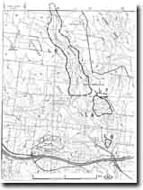
| Location: | Bullengarook - 695336 to Lerderderg - 706295. Shire of Bacchus Marsh. Valley of Korkuperrimul Creek from Tillite Creek extending 4 km downstream. | 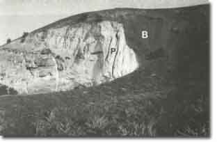 Korkuperrimul Creek - Glacial & Volcanic Rocks |
Access: | Londons Lane and Swans Lane. | |
Ownership: | Private land. | |
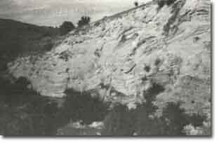
Site Description: | Sections exposed along the Korkuperrimul Creek and in old quarries on the valley slopes, display Permian glacial deposits of the Bacchus Marsh Formation and Older Volcanics lava flows. The glacial deposits form a composite section over 100 m thick and, as well as tillites, include outwash conglomerate, sandstone and siltstone deposited in lakes and streams marginal to the glaciers. The best sections are at Miers Cliff, Andersons Quarry and Tillite Creek. Two faulted contacts between Permian rocks and Older Volcanics basalt are well exposed in Korkuperrimul Creek, and jointed basalt and tuff is exposed in the creek bed and on valley-side bluffs at several localities. At Miers Creek confluence, Korkuperrimul Creek crosses a wide, resistant outcrop of Older Volcanics basalt and a short steep gorge has developed. Elsewhere along the creek are narrow stream terraces and higher level terraces containing large Older Volcanics boulders. | |
At Miers Cliff and near Long Gully, a lenticular conglomerate bed interbedded in the Bacchus Marsh Formation has been differentiated as the Morton Conglomerate Member. This is the only stratigraphic subdivision made of the Permian deposits. | ||
Several major publications refer to the detailed stratigraphy and geological history of the Permian deposits. | ||
Several major publications refer to the detailed stratigraphy and geological history of the Permian deposits at Korkuperrimul Creek. | ||
Significance: | International. The glacial beds exposed in Korkuperrimul Creek are part of a glacial episode that affected all of the Gondwanaland continents. This site displays a wide variety of Permian glacial deposits and the faulted nature of the contact with the Older Volcanic rocks. It also includes a major exposure of the Morton Conglomerate Member. | |
Management: | Class 1. The sites should be retained as natural outcrops. No construction activities that would modify or obscure the outcrops should be permitted. Retention of the sites under rural land use is appropriate to maintaining their significance. The main threat would be smaller sub-division involving stream control structures, bridges and causeways, and buildings. | |
References: | Bowen RL and Thomas GA (in Douglas JG and Ferguson JE) (1976) Crowell JC and Frakes LA (1971) Roberts P (1984, 1985) Jacobson R and Scott TR (1937) | |
 Korkuperrimul Creek | 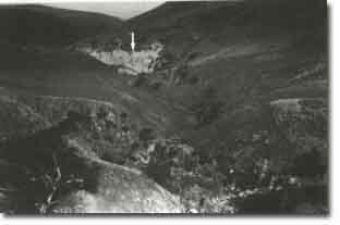 Korkuperrimul Creek - Glacial and Volcanic Rocks |

© State of Victoria (Agriculture Victoria) 1996 - .

This work, Victorian Resources Online, is licensed under a Creative Commons Attribution 4.0 licence. You are free to re-use the work under that licence, on the condition that you credit the State of Victoria (Agriculture Victoria) as author, indicate if changes were made and comply with the other licence terms.
The licence does not apply to ‘branding’ or some ‘images or photographs’ that may be owned by third parties. We ask you to seek prior approval to use images using the VRO feedback form. Access to higher quality images can also be provided on request.
This page was last updated on .