
L2 - Lerderderg River, Morven - Permian Glacial Rocks
|
This information has been developed from this publication:
|
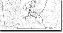
| Location: | Lerderderg - 728326 to 727317. Shire of Bacchus Marsh. Eastern bank of Lerderderg River extending for 800 m immediately west of ‘Morven” Farm. | 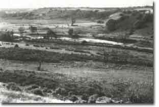 Lerderderg River - Morven - Permian Glacial Rocks |
Access: | Lerderderg Gorge Road. | |
Ownership: | Private land. | |
Site Description: | This site has been studied in considerable detail by several geologists, and only a very brief statement is included here. It is regarded as one of the most important Permian glacial sections in Victoria. | |
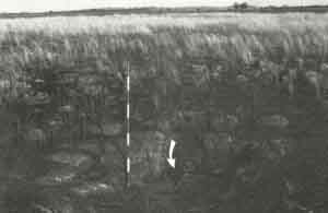
The river bank provides a nearly continuous 145 m section of Permian glacial deposits. A wide variety of glacial deposits is represented including tillite, glacial outwash sandstone and conglomerate, ice-rafted erratics dropped into sandstone beds, mudflow beds, and erosion surfaces. These marked changes inn deposition were produced by minor glacial fluctuations, and imbricated boulder pavements with striated surfaces show that the ice advanced and retreated numerous times. | ||
Unconformably overlying the Permian deposits are rounded boulder rocks deposited in recent times by the Lerderderg River. | ||
Significance: | International. The glacial beds of Bacchus Marsh are part of a glacial episode that affected all of Gondwanaland continents. The significance of this has been discussed above. The site displays a wide variety of glacial depositional and erosional features. | |
Management: | Class 1. Activity of any kind that would cover, damage or remove these outcrops should be prohibited. At this site, there is also damage to the exposure caused by bulldozing gravels from the river channel and heaping them against the bank. If it is necessary to continue this as a flood mitigation measure, the gravels should be piled against the right (west) bank of the river rather than the east banks against the Permian outcrops. Structures such as pump housings, weirs, windmills, etc that require solid footings should not be permitted on the left bank but should be located on the opposite side of the stream. Masonry walls of rock material not naturally occurring along the channel (basalt), have been used to protect the base of the bank from erosion and should be removed. Consideration should be given to acquiring the river banks into public ownership or control to ensure adequate protection of these significant outcrops. Landholders should be required to locate structures away from these areas and not to permit activities on the property that would cause the exposures to be obscured. | |
References: | Bowen RL and Thomas GA (in Douglas JG and Ferguson JE) (1976) Crowell JC and Frakes LA (1971) Roberts P (1984, 1985) | |
 Lerderderg River - Morven - Permian Glacial Rocks |

© State of Victoria (Agriculture Victoria) 1996 - .

This work, Victorian Resources Online, is licensed under a Creative Commons Attribution 4.0 licence. You are free to re-use the work under that licence, on the condition that you credit the State of Victoria (Agriculture Victoria) as author, indicate if changes were made and comply with the other licence terms.
The licence does not apply to ‘branding’ or some ‘images or photographs’ that may be owned by third parties. We ask you to seek prior approval to use images using the VRO feedback form. Access to higher quality images can also be provided on request.
This page was last updated on .