
I6 - Parwan Valley - Rockfall Scarp, Falls
|
This information has been developed from this publication:
|
| Location: | Ingliston - 593293. Shire of Ballan. Headwaters of Yaloak Creek, 1 km south of ‘Craiglea’. | 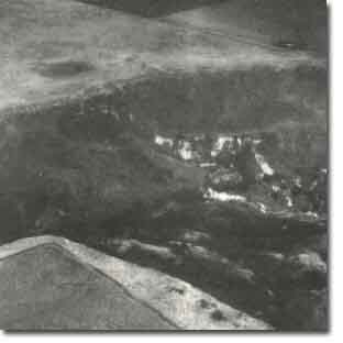 Parwan Valley - Rockfall Scar, Falls |
Access: | Ballan - Ingliston Road. | |
Ownership: | Private land. | |
Site Description: | The site includes the knick point and waterfall 12 m high where the Parwan Creek crosses the basalt escarpment. On the eastern side of the valley, 200 m south of the knick point, is a massive landslip involving block collapse of a broad sector of the escarpment. The factors involved in this movement are complex. The collapse has generated a rock flow/slide of large basalt blocks and boulders, which has overidden older scree deposits and caused deformation of underlying Tertiary sediments. The escarpment here includes at least 3 lava flows with weathered tuffs at the flow interface. Strong vertical jointing extends through the lava sequence and the joints have become enlarged by seepage hollows developing in the plateau near the escarpment edge. The initial movement appears to have been in the basal screes, which have slumped away from the partially buried escarpment (due probably to slip movements in the underlying Tertiary sediments), and the removal of this support has allowed collapse of the scarp face. | |
Significance: | State. The site is one of the largest mass movements in Victoria and is of considerable complexity. It is an active landslide site and provides opportunity for detailed study. The active waterfall is an excellent illustration of one major factor in generating scarp movement. | |
Management: | Class 1. The site poses a considerable hazard to any forms of land use. The escarpment edge is unstable and the lower slopes are liable to substantial sudden and rapid movement. Because of the scale of the mass movement, there is little point in attempting to arrest the process. The site is best retained as a geological and geomorphological reference site to allow close monitoring of the landslip mechanisms. | |

© State of Victoria (Agriculture Victoria) 1996 - .

This work, Victorian Resources Online, is licensed under a Creative Commons Attribution 4.0 licence. You are free to re-use the work under that licence, on the condition that you credit the State of Victoria (Agriculture Victoria) as author, indicate if changes were made and comply with the other licence terms.
The licence does not apply to ‘branding’ or some ‘images or photographs’ that may be owned by third parties. We ask you to seek prior approval to use images using the VRO feedback form. Access to higher quality images can also be provided on request.
This page was last updated on .