
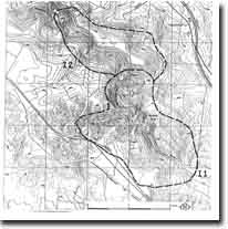
I2 - The Island - Palaeotopography
|
This information has been developed from this publication:
|
| Location: | Ingliston - 660295. Shire of Bacchus Marsh. Narrow ridge between Werribee River and Myrniong Creek near their junction. | |
Access: | From Werribee Gorge State Park. | |
Ownership: | Private land. | |
Site Description: | ‘The Island’ is a steep, narrow, lava-capped ridge at the junction of the Werribee River and Myrniong Creek - the lava capping the ridge being continuous with the flow from Mount Blackwood. This flow filled the ancestral valley of the Myrniong Creek and the present stream is lateral to the lava for some distance. The old river channel is exposed at several places along the valley sides of the Myrniong Creek and on the Werribee River to the south. At the point where the Myrniong Creek turns east along the northern side of ‘The Island’, it is only 250 m from the Werribee River (although 100 m above it) and is separated only by a low basaltic ridge. The valley of the creek, however, trends east for 2 km, looping around ‘The Island’ and rapidly steepening in grade before entering the Werribee River. This section of the stream may originally have been a short tributary which captured the lower course of the main creek, hence diverting it to the east. | |
Several important geological sections are exposed on the sides of ‘The Island’. On the northern side is a substantial section of the Permian glacial materials with the base of the Permian exposed resting on Ingliston Granite, while on the southern side the Permian is faulted against the granite and Ordovician sediments. There are sufficient exposures of the sub-basaltic ancestral Werribee River to allow reconstruction of the ancient course of that stream. | ||
Significance: | State. The site displays a major section in the Permian materials, and is particularly important for the exposure of the palaeotopography on which the Permian rocks rest. The valley of the Myrniong Creek also exposes sub-basaltic valleys and is of interest for the marked deviation of course and steepening of grade which suggest a history of stream capture. | |
Management: | Class 2. Because of the geological and geomorphological relationship of this site to features of the Werribee Gorge, it should be desirable to incorporate it in the Werribee Gorge State Park. To avoid obscuring important sections and to alleviate slope degradation, building construction, cultivation, and roadworks should not be permitted on the site. | |
References: | Roberts PS (1984) | |

© State of Victoria (Agriculture Victoria) 1996 - .

This work, Victorian Resources Online, is licensed under a Creative Commons Attribution 4.0 licence. You are free to re-use the work under that licence, on the condition that you credit the State of Victoria (Agriculture Victoria) as author, indicate if changes were made and comply with the other licence terms.
The licence does not apply to ‘branding’ or some ‘images or photographs’ that may be owned by third parties. We ask you to seek prior approval to use images using the VRO feedback form. Access to higher quality images can also be provided on request.
This page was last updated on .