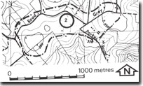
2. Gembrook East Lava Residual
|
This information has been developed from one or more of these publications:
|
| Location: | Gilwell – 750982. Three kilometres east of Gembrook | |
Access: | Beenak East Road. | |
Ownership: | Private land and Crown Land. | |
Geology/Geomorphology: | The site includes an area on the watershed between the Westernport stream system and the tributaries of the Yarra River. The Beenak East Road traverses a ridge of Older Basalt that rests on a weathered and eroded surface of Tynong Granite. At the junction of Grey and Parker roads, there is a low point on the divide referred to in early literature as the Gembrook Gap or Beenak Gap (Edwards, 1940). This region figured prominently in the early literature as a possible site of a pre-basaltic stream system extending from the Woori Yallock Basin towards the south and hence crossing the present divide. | |
Significance: | Regional. The site is of particular interest in the context of early geomorphological discussion on the evolution of the Yarra and Westernport drainage systems. | |
Management: | Class 3. No special management is required to maintain the characteristics of the site. | |
References: | Gregory (1903) Keble, R.A. (1918). The significance of lava residuals in the development of Western Port and Port Phillip drainage systems. Proc. Roy. Soc. Vict. (31) 1 124-165. Edwards, A.B. (1940). A note on the physiography of the Woori Yallock Basin. Proc. Roy. Soc. Vict. 52 (1) 336-341. | |


