G14 - Meander Scrolls and Abandoned Channels
|
This information has been developed from the publications:
|
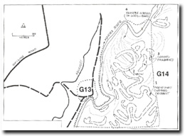
| Location: | AMG Ref: 535280. |  Abandoned channels occupy the western edge of the Yarra River flats (G14) to the west of the Yarra Fault scarp |
Access: | Private roads, MMBW Aqueduct Road. | |
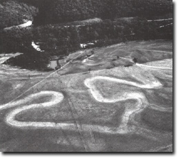
Geomorphology: | The site includes part of the scarp of the Yarra Fault, an area of higher level alluvium and a sequence of abandoned channels of the Yarra River. The latter occur to the east of the present channel which is now positioned at the western edge of the floodplain. Four separate groups of abandoned channel forms occur. | |
1. Abandoned channel segment. This can be traced continuously for 1 500 metres and is a result of a single shift of channel position. | ||
2. Oxbow. This is a single cutoff with a classical symmetrical oxbow form. | ||
3. Channel fragments. These are numerous small and generally indistinct shallow depressions marking the site of former cutoffs. | ||
4. Meander scrolls or scroll bars. These are low ridges marking the site of former slip-off slope bars stranded by the migration of a meander. | ||
Significance: | Regional. The abandoned meander channels and scroll bars indicate a channel sinuosity in the past of greater complexity than at present. This may have developed at a time when flow through the Yering Gorge was temporarily impeded, perhaps related to movements of the Yarra Fault. | |
Management: | Class 2. As the abandoned meander channels are now dry, agricultural use has reclaimed them to the extent that they are difficult to distinguish on the ground. Maintenance of the present level of agricultural intensity is compatible with preserving the features so they may be readily determined from aerial photographs. | |


