69. Flinders - Coastal Bluff and Cliff
|
This information has been developed from one or more of these publications:
|
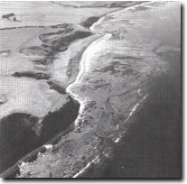
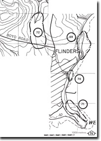
| Location: | Flinders 282406 to 282415. Approximately 1.5 kilometres north of Flinders jetty. |  Coastal cliffs, bluffs, beach ridges and wide shore platform north of Flinders |
Access: | Beach walk from Flinders jetty. | |
Ownership: | Private land and Crown Land. | |
Geology/Geomorphology: | The site includes a well defined coastal bluff fronted by a series of low, parallel sand and gravel beach ridges. To the north and south of the bluff sector there are marine cliffs cut in strongly jointed basalt and agglomerate. The cliffs are fringed by a shore platform up to 70 metres wide. The platform has an irregular surface due to uneven weathering of the several lava flows. There are several bowl-shaped depressions on the plateau surface at the top of the coastal bluff which result from landslide activity. | |
Significance: | State. This is a very clear example of the isolation of a former marine cliff by accretion of beach ridges. The bluffs resulting from this isolation contrast markedly in profile with the adjacent marine cliffs. It is an important site in the context of Victoria to demonstrate this process. | |
Management: | Class 2. Quarrying of the beach ridge sequence in front of the bluff, or any form of harbour construction should not be permitted on the area of the site. | |
 Site 69, Flinders area |


