140. Cobb Bluff - Coastal Cliffs
|
This information has been developed from one or more of these publications:
|
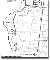
Location: | Corinella – 627435. 1 km south of Coronet Bay. | |
| Access: | Cutty Sark Road. | |
| Ownership: | Private land. | |
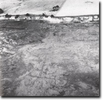
| Geology/Geomorphology: | An outcrop of deeply weathered basalt and tuff forms a spectacular active cliff sector that extends for 1 km south of Coronet Bay. The cliff profiles vary from a simple ‘J’ curve to complex ‘slope over wall’ forms. Most have a well-defined erosion notch at the base and are fronted by a shore platform up to 70 m wide developed in strongly jointed basalt. The basalt of the platform disintegrates to small corestones and some of these lodge at the cliff foot to form narrow beaches. There is relatively little gullying on the cliff face and no major slips or slumps are active at present. The volcanic materials weather by desiccation and move by slope wash to the cliff foot where they are readily dispersed. In a narrow stripped zone at the cliff top are large deep cracks parallel to the cliff line suggesting that large scale slumping or block detachment may occur. | |
| Significance: | State. The cliffs provide a clear cross-section of weathered Older Volcanics. The depth of weathering in the Older Volcanics is as great as at Corinella but the cliff profile at Cobb Bluff is less affected by large scale slumping. The sector constitutes an assemblage of cliff forms uncommon to the Victorian coast and provides opportunity for close study of weathering in the Older Volcanics and the rate of change of cliff profiles in these materials when exposed to direct wave action. | |
| Management: | Class 1. Coastal protection or cliff stabilization works should not be carried out and construction of boating facilities should be prohibited in the area of the site. Any roadways must be located at least 50 m landward of the cliff top and no surface or underground drainage lines should be directed across the site. No buildings should be permitted within 100 m of the cliff top. | |
 Wide shore platform and coastal cliffs at Cobb Bluff (photo taken at low tide). Arrow shows direction of Cobb Bluff profiles, which was taken at high tide, Site 140 |


