
Bu6 - Lerderderg Gorge - Incised Valley
|
This information has been developed from this publication:
|
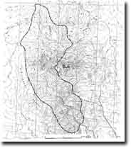
| Location: | Greendale - 670460 to Bullengarook - 723338. Shire of Ballan and Bacchus Marsh. Gorge of Lerderderg River extending from Nolan Gully south to the Lerderderg ford. | 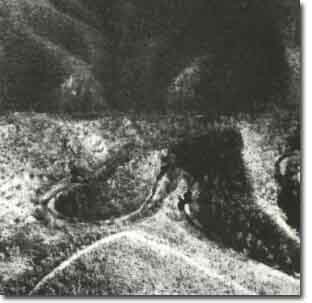 Lerderderg Gorge - Incised Valley |
Access: | Lerderderg Track, Nolan Track, Darley Road. | |
Ownership: | Crown land. | |
Site Description: | The Lerderderg Gorge is the valley deeply incised by the Lerderderg River into the fault blocks upthrown by movement of the Rowsley, Greendale and Coimadai Faults. The gorge is over 300 m deep with valley-side slopes commonly of 35o to 40o and near-vertical rocky cliffs to 60 m high. The topography of the area is dominated by long narrow ridges and steep secondary spurs, with a high degree of rock outcrop on ridge crests, slopes and stream channels. The geology is dominantly of folded Lower Ordovician sandstones and mudstones intruded by numerous small quartz veins and several larger and longer acid dykes. There are excellent exposures of the Ordovician sediments displaying bedding, depositional structures, fracturing and folding at many localities along the gorge. Although some sectors of stream channel are strike-aligned, the general trends of the valley is oblique to the direction of the strike of the Ordovician rocks. The stream gradient is steep, has a coarse bouldery load and the river follows a tortuous course with several deeply incised gooseneck meanders. In places narrow boulder terraces grading into finer grained sediments flank the channel and occur at least three levels. | |
Significance: | State. The Lerderderg Gorge is one of the major valley features of the state of Victoria. It provides an outstanding illustration of stream rejuvenation resulting from faulting and provides an extensive section of the lithology and structures of the Lower Ordovician sediments. | |
Management: | Class 2. The major physiographic features of the gorge are robust and are appropriately protected by the status of most of the area as a State Park. Monitoring of the impact of off-road vehicles and excessive pedestrian traffic on some unstable slopes will be necessary. It would be desirable if a detailed survey of the geological and geomorphological features of the Lerderderg Gorge was undertaken by (or for) the National Parks Service (similar to that prepared for the Werribee Gorge). | |
 Site - Bu6 |

© State of Victoria (Agriculture Victoria) 1996 - 2025.

This work, Victorian Resources Online, is licensed under a Creative Commons Attribution 4.0 licence. You are free to re-use the work under that licence, on the condition that you credit the State of Victoria (Agriculture Victoria) as author, indicate if changes were made and comply with the other licence terms.
The licence does not apply to ‘branding’ or some ‘images or photographs’ that may be owned by third parties. We ask you to seek prior approval to use images using the VRO feedback form. Access to higher quality images can also be provided on request.
This page was last updated on 23/11/2018.