
Bu2 - Bullengarook - Cataract Creek Falls
|
This information has been developed from this publication:
|
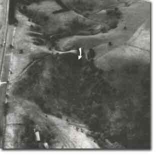
| Location: | Bullengarook - 763408. Shire of Bacchus Marsh. Eastern side of Bullengarook lava flow 15 km north of Bacchus Marsh. | 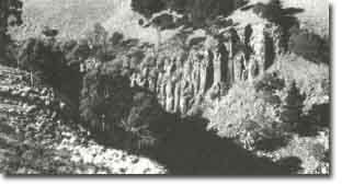 Bullengarook - Cataract Creek Falls |
Access: | Bacchus Marsh to Gisborne Road. | |
Ownership: | Private land. | |
Site Description: | Cataract Creek rises on the slopes of Mount Bullengarook and drains across the lava flow towards the south to join Pyrites Creek. The stream crosses the edge of the lava via a narrow valley and a 30 m high waterfall at the head of a deep gorge before joining Pyrites Creek. The falls and gorge expose a broad section of the columnar jointed lavas of the Bullengarook stream at the base of the lava. Substantial blocky screes are forming from the break-up of columnar jointed lavas at the falls and in the gorge. | |
A radiometric age determination by the potassium - argon method has dated the lava flow here as from 3.3 million to 3.6 million years old. | ||
Significance: | State. The site displays the best natural section available of the Bullengarook lava flow and is an outstanding example of the processes that led to the relief inversion. No comparable active sites exist elsewhere on the Bullengarook flow. | |
Management: | Class 1. No diversion or damming of the Cataract Creek should be permitted as this would diminish the activity of the falls and the rate of gorge development. No excavations, road works or construction activity that generated rock rubble on the slopes of the Cataract Creek should be permitted in the area of the site. Because the site has considerable scenic as well as scientific interest, provision for public access to the area could be considered and no further construction permitted in the area of the site. | |
References: | Crawford W (1940) Roberts P (1984) | |
 Cataract Creek Falls | 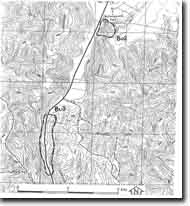 Site - Bu2 - 3 |

© State of Victoria (Agriculture Victoria) 1996 - .

This work, Victorian Resources Online, is licensed under a Creative Commons Attribution 4.0 licence. You are free to re-use the work under that licence, on the condition that you credit the State of Victoria (Agriculture Victoria) as author, indicate if changes were made and comply with the other licence terms.
The licence does not apply to ‘branding’ or some ‘images or photographs’ that may be owned by third parties. We ask you to seek prior approval to use images using the VRO feedback form. Access to higher quality images can also be provided on request.
This page was last updated on .