
5. Black Snake Range - Granite Slopes
|
This information has been developed from one or more of these publications:
|
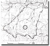
| Location: | Beenak – 815967. Ten kilometres east of Gembrook. | |
Access: | Burgess Road or Back Creek Road. | |
Ownership: | Crown Land. | |
Geology/Geomorphology: | The Black Snake Range is a prominent east-west divide developed in the Tynong Granite. The crest of the divide rises to almost 400 metres and at this site there are numerous exposed granite slopes and large boulders near the ridge crest. The lower slopes have a cover of granite downwash and the minor valleys have become partly infilled with this granitic sand wash, and hence they are swampy. A scrub and heathland vegetation on these lower slopes reflects these impede drainage conditions. | |
Significance: | Regional. The site is typical of the lower ranges that form the upper catchment of the main tributaries of the Bunyip River. | |
Management: | Class 2. Extensive clearing or sand extraction should not be permitted at the site. | |

© State of Victoria (Agriculture Victoria) 1996 - .

This work, Victorian Resources Online, is licensed under a Creative Commons Attribution 4.0 licence. You are free to re-use the work under that licence, on the condition that you credit the State of Victoria (Agriculture Victoria) as author, indicate if changes were made and comply with the other licence terms.
The licence does not apply to ‘branding’ or some ‘images or photographs’ that may be owned by third parties. We ask you to seek prior approval to use images using the VRO feedback form. Access to higher quality images can also be provided on request.
This page was last updated on .