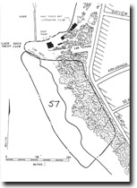
57. Black Rock Point - Cliff Complex
|
This information has been developed from one or more of these publications:
|
| Location: | 252954. Coastal cliffs, bluffs, beach and shore platform extending for 350 m south of the access road to Half Moon Bay. | |
Access: | Off Beach Road south of Bayview Cr, Black Rock. | |
Ownership: | Crown land, City of Sandringham. | |
Geology/Geomorphology: | Black Rock Point is a cliffed promontory of soft Red Bluff Sand with a shore platform developed on harder ferruginous Black Rock Sandstone. The point has been greatly modified by boating facility development. South of the Yacht Club and parking areas and extending over 350 m, there are 3 small embayment backed by rilled cliffs, with narrow beaches derived from alluvial and gully fans, behind an uneven and in places boulder-strewn shore platform averaging 20 m wide. There are very clear sections of the two geological formations including extensive exposure of a coarse grit which may mark the discontinuity between them. High tides cover part of the platform but wave action attacks the cliff base only during storms. The most rapid geomorphological process operating at the site is the development of rills and small gullies in the soft sandy clay sediments of the Red Bluff Sand. On the cliff top, a kitchen midden of shell, charcoal and other organic material is buried by dune sand. | |
Significance: | State. The site is an extensive and safely accessible exposure of the contact between the Black Rock Sandstone and the Red Bluff Sand. There are many geological and geomorphological features displayed, including bedding, gently dipping beds, contrasts in texture and fabric sediments, degrees of ferruginisation and weathering, and development of rills, beaches and shore platforms. The site is the subject of a detailed monitoring programme (commenced in 1971) to document the rates and processes of cliff, platform and beach development. It is an excellent teaching and research site and provides the only opportunity for demonstrating the evolution and dynamics of the cliff, bluff and beach systems of the northeast coast of Port Phillip Bay. | |
Management: | Class 1. Detailed monitoring has shown that the rate of cliff recession poses no threat to public or private property. The site should therefore be retained as a reference site without further extensive engineering works. Low level southward extension of the car parking area at Black Rock should not be permitted, and no sea walls, groynes or other protective structures are warranted. Limited control of cliff top and cliff face drainage may be necessary to reduce the rate of rill development on the southern cove. Such work should be undertaken only with adequate geological/geomorphological advice and aimed at preserving the major cliff and platform features, including the cliff-top kitchen midden. | |
References: | Gill, E.D. (1857). The stratigraphical occurrence and palaeoecology of some Australian Tertiary marsupials. Mem. Nat. Mus. Vict., 21, 135-203. Bird, E.C.F., Cullen, P. & Rosengren, N.J. (1973). Conservation problems at Black Rock Point. Vic., Nat., 90 (9), 240-247. Bird, E.C.F. & Rosengren, N.J. (1987). Coastal cliff management: an example from Black Rock Point, Melbourne, Australia. J. Shoreline Management, 3, 39-51. King, R. L., Cochrane, R.M. & Cooney A.M. (1987). Significant geological features along the coast in the City of Sandringham. Unpub. rep. geol. Surv. Vict., 1987/35. | |


