
40. Baxter - Middle Miocene Sediments
|
This information has been developed from one or more of these publications:
|
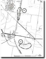
| Location: | Baxter – 400696. Watson Creek, two kilometres east-south-east of Baxter railway station. | |
| Access: | Henderson Road. | |
| Ownership: | Private land. | |
| Geomorphology: | Chapman (1921) reported a ‘sandy ironstone band …..crossing Watsons Creek….half a mile west of the Baxter Railway station’. The bed contained fossil casts and was subsequently described by Keble (1950) as a sandy claystone, and positioned by him as '1.3 miles east-south-east of Baxter railway station’. The outcrop has not been located in the field during this survey. | |
| Significance: | Regional. The stratigraphical position of these beds has not been exactly determined, but they are regarded by Jenkin (1974) as the probable equivalents of the Balcome Clay. The site represents the only documented outcrop of this formation in the study area. | |
| Management: | Class 2. Extensive filling or construction activities that obscure the creek channel should not be permitted. | |
References: | Chapman (1921). Keble (1950). Gostin, V.A. (1966). Tertiary stratigraphy of the Mornington District, Victoria. Proc. Roy. Soc. Vict. 79 (2) 459-512. Jenkin, J.J. (1974). The geology of the Mornington Peninsula and Westernport. Geol. Surv. Rept. No. 1974/3. | |

© State of Victoria (Agriculture Victoria) 1996 - .

This work, Victorian Resources Online, is licensed under a Creative Commons Attribution 4.0 licence. You are free to re-use the work under that licence, on the condition that you credit the State of Victoria (Agriculture Victoria) as author, indicate if changes were made and comply with the other licence terms.
The licence does not apply to ‘branding’ or some ‘images or photographs’ that may be owned by third parties. We ask you to seek prior approval to use images using the VRO feedback form. Access to higher quality images can also be provided on request.
This page was last updated on .