
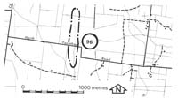
96. Cantani - Alluvial Ridge
|
This information has been developed from one or more of these publications:
|
Location: | Catani - 850710. Four kilometres east of Catani. | |
Access: | North Yanathan Road. | |
Ownership: | Private land. | |
Geomorphology: | Low, parallel sandy ridges are former levee banks of an alluvial fan stream draining to the north from the Heath Hill escarpment. This may have been one of the distributaries of the Lang Lang River before the development of the Koo-Wee-Rup Swamp. | |
Significance: | Local. The ridges are minor landscape features but are important in illustrating the development of the lowlands in this area. | |
Management: | Class 2. Extensive building construction, excavation, or levelling of the area should not be permitted. | |

© State of Victoria (Agriculture Victoria) 1996 - .

This work, Victorian Resources Online, is licensed under a Creative Commons Attribution 4.0 licence. You are free to re-use the work under that licence, on the condition that you credit the State of Victoria (Agriculture Victoria) as author, indicate if changes were made and comply with the other licence terms.
The licence does not apply to ‘branding’ or some ‘images or photographs’ that may be owned by third parties. We ask you to seek prior approval to use images using the VRO feedback form. Access to higher quality images can also be provided on request.
This page was last updated on .