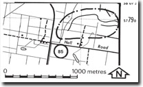
85. Pakenham South - Sinuous Ridges
|
This information has been developed from one or more of these publications:
|
| Location: | Tooradin – 678787. Eight kilometres north of Koo-Wee-Rup. | |
| Access: | Hall Road and Ellet Road. | |
| Ownership: | Private land. | |
| Geomorphology: | The site lies on the northern margin of the drained Koo-Wee-Rup swamplands. Rising very slightly (e.g. one metre) above the former swamp surface are a number of narrow sinuous ridges. These consist of a clayey gravel (Jenkin, 1974), and are the channels of stream courses that extended across these lowlands before the accumulation of the main body of freshwater swamp sediments. Hills (1942) suggested that these represented the abandoned levees and bed deposits of distributary channels of alluvial fans developed during a more arid phase in the late Pleistocene. | |
| Significance: | Regional. The ridges are an important feature in determining the late Quaternary history of the Koo-Wee-Rup lowlands. | |
| Management: | Class 3. The ridges are often difficult to detect on the ground owing to their very low relief. Small barrow pits are of interest as they provide sections into the deposits. Extensive subdivision or other construction that covered a high percentage of the area should not be permitted as this would destroy the essential features of the site. | |
References: | Hills, E.S. (1942). The physiography of the Koo-Wee-Rup Swamp. Proc. Roy. Soc. Vict. 54 (1) 79-92. Jenkin, J.J. (1974). The geology of the Mornington Peninsula and Westernport. Geol. Surv. Rept. No. 1974/3. | |


