|
This information has been developed from one or more of these publications:
- Sites of Geological and Geomorphological Significance in the Westernport Bay Catchment (1984) by Neville Rosengren.
- Sites of Geological and Geomorphological Significance in the Western Region of Melbourne (1986) by Neville Rosengren
- Sites of Geological and Geomorphological Significance on the Coast of Port Phillip Bay (1988) by Neville Rosengren.
- Sites of Environmental Significance in the Flood Plain of the Upper Yarra Valley Region (1983) by Neville Rosengren, Douglas Frood and Kim Lowe (as part of a study of Sites of Environmental Significance by the University of Melbourne for the then Upper Yarra Valley and Dandenong Ranges Authority).
Geological heritage sites, including sites of geomorphological interest and volcanic heritage sites, are under regular revision by the Geological Society of Australia, especially in the assessment of significance and values. Reference should be made to the most recent reports. See the Earth Science Heritage section of the Geological Society of Australia website (external link) for details of geological heritage reports, and a bibliography. |
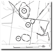
| Location: | Baxter – 456677. Two kilometres south of Pearcedale. | 
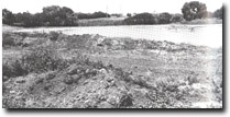
Dune Lake, Pearcedale, Site 42 |
| Access: | Tyabb – Tooradin Road. |
| Ownership: | Private land. |
| Geomorphology: | A small lake and swamp-filled depression is a deflection hollow in a ridge of Cranbourne Sand. |
| Significance: | Local. Wetlands of this type were formerly more common in the area but most have been drained and cleared. Although this site has been subsequently modified with artificial sand islands constructed and excavation and filling on some banks, it still displays the form and dimensions of a dune lake. |
| Management: | Class 3. Further drainage works or construction of embankments should not to be permitted. |

Site 42, dune swamps and lakes - Pearcedale


