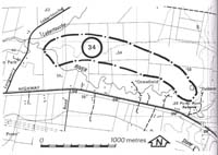
34. Tarago river - Abandoned Floodway
|
This information has been developed from one or more of these publications:
|
| Location: | Labertouche - 945845. Six kilometres north-west of Drouin. | |
Access: | Princes Highway. | |
Ownership: | Private land. | |
Geomorphology: | The present channel of the Tarago River east of Picnic Point Reserve is incised five metres into the flood plain, and trending parallel to this course and at 200 m branches off at Picnic Point Reserve. This channel rejoins the Tarago River just upstream from the junction of the Labertouche Creek. This floodway is now abandoned as it is well above the incise channel of the Tarago River. | |
Significance: | Regional. The site illustrates one aspect of channel morphology of the flood plain of the Tarago River. | |
Management: | Class 3. Changes in land use will not reduce the significance of the site. | |


