
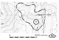
30. Labertouche Caves - Granite Caves
|
This information has been developed from one or more of these publications:
|
| Location: | Labertouche - 988929. Seven kilometres north-east of Labertouche. | |
Access: | Jacksons Track of Labertouche Road. | |
Ownership: | Crown land. | |
Geology/Geomorphology: | Labertouche cave is a stream passage cave developed in Tynong Granite. It is occupied by a tributary of Labertouche Creek which flows underground for a distance of 175 metres. The accessible cave section is slightly shorter than this and is entered through an old stream sink located above the currently active stream passages. The cave consists of a passage through a pile of corestones of granite and in places there are exposures of in situ granite. Vigorous stream flow is maintained, which transports sand and gravel through the cave. Grooved and polished boulder surfaces found at several levels throughout the cave illustrate the abrasive action of this transported sediment. A smaller cave 200 metres to the east is on another tributary stream, but as yet no accessible cave passage has been discovered to this cave. | |
Significance: | National. There are only three known accessible cave passages in acid igneous rocks in Victoria, and there are few other examples in Australia. As cave development in this lithology is rare, the precise mode of origin of the Labertouche Cave is not known. The site is therefore of considerable importance for the study of weathering, mass wasting and stream passage development. | |
Management: | Class 1. Quarrying, roadworks, or any construction activities at and upstream of the cave site should be completely prohibited. The valley slopes adjacent to the site and on the tributaries upstream should not be cleared, or be permitted to be inundated by water storage or diversion schemes. No activity that would generate debris or waste should be allowed in the catchment of the site as this could block or divert stream flow and obscure the cave entrances. | |
References: | Finlayson (1981). | |

© State of Victoria (Agriculture Victoria) 1996 - 2025.

This work, Victorian Resources Online, is licensed under a Creative Commons Attribution 4.0 licence. You are free to re-use the work under that licence, on the condition that you credit the State of Victoria (Agriculture Victoria) as author, indicate if changes were made and comply with the other licence terms.
The licence does not apply to ‘branding’ or some ‘images or photographs’ that may be owned by third parties. We ask you to seek prior approval to use images using the VRO feedback form. Access to higher quality images can also be provided on request.
This page was last updated on 23/11/2018.