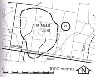
22. Mt. Ararat - Older Volcanics Eruption Point
|
This information has been developed from one or more of these publications:
|
| Location: | Nar Nar Goon - 726861. Immediately north of the Princess Highway seven kilometres east of Pakenham. | |
Access: | Princes Highway. | |
Ownership: | Private land. | |
Geology: | Mount Ararat is the highest point of a north-south trending ridge of Older Volcanics basalt. It is conical in form and has been identified as an eruption point. | |
Significance: | State. This is one of number of Older Volcanics erosion residuals on and south of the ranges in the northern part of the Westernport catchment. It is one of the small number of localities identified as an eruption point of the Older Volcanics lavas. | |
Management: | Class 2. Quarrying could be permitted on the slopes as this would assist in displaying the nature of the eruption point. Extensive construction or close subdivision of the upper slopes and crest should be prohibited as this would mask the nature of the volcanic features. | |


