
162. Cooke Hill - Mesozoic Sediments
|
This information has been developed from one or more of these publications:
|
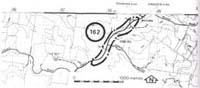
| Location: | Korumburra - 982515. Six kilometres north of Korumburra south of the junction of the Poowong to Ranceby road. | 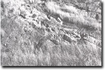 Scour channel (arrowed) in Mesozoic sediments at Cooke Hill. |
Access: | Warragul to Korumburra road. | |
Ownership: | Crown Land. | |
Geology: | Several cuttings on the Warragul to Korumburra road provide one of the most extensive inland sections available in the Westernport Bay catchment of the Mesozoic sedimentary rocks. The cuttings are on the western slopes of Cooke Hill and extend for several hundred metres south from the junction with the Poowong road. The sections were measured and described in some detail of the beds. The sections include massive sandstones up to five metres thick, thinner bedded carbonaceous mudstones and siltstones, and seams of black coal. Power (1971) referred to this section as displaying excellent examples of the sedimentary processes occurring in the Mesozoic depositional basin. These examples include a large scour channel with calcareous concretions and a mud pebble conglomerate, and a slumped and deformed cloak of arkose contained within these fill deposits. | |
Significance: | State. The section is one of the best exposed and documented of the inland exposures of Mesozoic sediments in the Westernport Bay Catchment. | |
Management: | Class 1. The site illustrates the difficulty of maintaining exposures on artificial slopes such as road cuttings. The Mesozoic rocks weather quickly. Without some process to remove the accumulated weathered material and vegetation, the section has quickly become obscured. To maintain the significance of the site it will be necessary to periodically mechanically clear the face. Artificial materials should not be placed on the slope to stabilise it as this would further cover the rock exposure. | |
References: | Tickell, S.J., 1971. The geology of the Bass River Area. B.Sc. Hons thesis (unpub.) Dept. of Geol. Univ. of Melb. Power (1971). | |

© State of Victoria (Agriculture Victoria) 1996 - .

This work, Victorian Resources Online, is licensed under a Creative Commons Attribution 4.0 licence. You are free to re-use the work under that licence, on the condition that you credit the State of Victoria (Agriculture Victoria) as author, indicate if changes were made and comply with the other licence terms.
The licence does not apply to ‘branding’ or some ‘images or photographs’ that may be owned by third parties. We ask you to seek prior approval to use images using the VRO feedback form. Access to higher quality images can also be provided on request.
This page was last updated on .